
Topografische kaart Kedarkantha
Interactieve kaart
Klik op de kaart om de hoogte weer te geven.
Over deze kaart
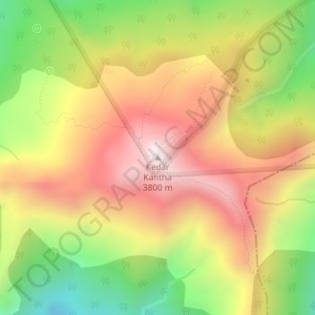
Naam: Topografische kaart Kedarkantha, hoogte, reliëf.
Locatie: Kedarkantha, Mori, Uttarkashi, India (31.02248 78.17185 31.02258 78.17195)
Gemiddelde hoogte: 3.404 m
Minimale hoogte: 2.947 m
Maximale hoogte: 3.811 m
Kedarkantha is a mountain peak of the Himalayas in Uttarakhand, India. Its elevation is 12,500 ft (3,800 m). Kedarkantha is located within Govind Wildlife Sanctuary in Uttarkashi district.
Andere topografische kaarten
Klik op een kaart om zijn topografie, zijn hoogte en zijn reliëf te bekijken.