
Topografische kaart Louisville
Interactieve kaart
Klik op de kaart om de hoogte weer te geven.
Over deze kaart
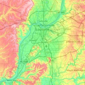
Naam: Topografische kaart Louisville, hoogte, reliëf.
Locatie: Louisville, Jefferson County, Kentucky, United States (37.99710 -85.94706 38.38014 -85.40510)
Gemiddelde hoogte: 188 m
Minimale hoogte: 114 m
Maximale hoogte: 306 m
Throughout January 1937, 19.17 inches (48.7 cm) of rain fell in Louisville, and by January 27, the Ohio River crested at a record 57.15 feet (17.42 m), almost 30 feet (9.1 m) above flood stage. These events triggered the "Great Flood of 1937", which lasted into early February. The flood submerged 60–70 percent of the city, caused complete loss of power for four days, and forced the evacuation of 175,000 or 230,000 residents, depending on sources. Ninety people died as a result of the flood. It led to dramatic changes in where residents lived. Today, the city is protected by numerous flood walls. After the flood, the areas of high elevation in the eastern part of the city had decades of residential growth.
Andere topografische kaarten
Klik op een kaart om zijn topografie, zijn hoogte en zijn reliëf te bekijken.
Indian Hills Cherokee Section
United States > Kentucky > Jefferson County > Indian Hills
Indian Hills Cherokee Section, Indian Hills, Jefferson County, Kentucky, 40207, United States
Gemiddelde hoogte: 168 m
Louisville
United States > Kentucky > Jefferson County > Louisville
Louisville, Jefferson County, Kentucky, 40202-2923, United States
Gemiddelde hoogte: 180 m
E.P. "Tom" Sawyer State Park
United States > Kentucky > Jefferson County > Louisville > Lakeland
E.P. "Tom" Sawyer State Park, Lakeland, Louisville, Jefferson County, Kentucky, United States
Gemiddelde hoogte: 209 m
Worthington
United States > Kentucky > Jefferson County > Louisville
Worthington, Louisville, Jefferson County, Kentucky, 40241, United States
Gemiddelde hoogte: 208 m
Turkey Run
United States > Kentucky > Jefferson County > Louisville
Turkey Run, Louisville, Jefferson County, Kentucky, United States
Gemiddelde hoogte: 178 m
Prospect
United States > Kentucky > Jefferson County
Prospect, Jefferson County, Kentucky, United States
Gemiddelde hoogte: 166 m
Thornhill
United States > Kentucky > Jefferson County
Thornhill, Jefferson County, Kentucky, United States
Gemiddelde hoogte: 180 m
Forest Hills
United States > Kentucky > Jefferson County > Forest Hills
Forest Hills, Jefferson County, Kentucky, United States
Gemiddelde hoogte: 202 m
Anchorage
United States > Kentucky > Jefferson County > Anchorage
Anchorage, Jefferson County, Kentucky, United States
Gemiddelde hoogte: 219 m
Riverside Gardens
United States > Kentucky > Jefferson County > Louisville
Riverside Gardens, Louisville, Jefferson County, Kentucky, 40216, United States
Gemiddelde hoogte: 136 m
Coldstream
United States > Kentucky > Jefferson County
Coldstream, Jefferson County, Kentucky, United States
Gemiddelde hoogte: 219 m
Saint Dennis
United States > Kentucky > Jefferson County > Louisville
Saint Dennis, Louisville, Jefferson County, Kentucky, 40216, United States
Gemiddelde hoogte: 138 m