
Topografische kaart Abilene
Interactieve kaart
Klik op de kaart om de hoogte weer te geven.
Over deze kaart
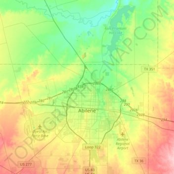
Naam: Topografische kaart Abilene, hoogte, reliëf.
Locatie: Abilene, Taylor County, Texas, United States (32.34319 -99.86759 32.62448 -99.62308)
Gemiddelde hoogte: 533 m
Minimale hoogte: 481 m
Maximale hoogte: 615 m
Andere topografische kaarten
Klik op een kaart om zijn topografie, zijn hoogte en zijn reliëf te bekijken.
Ovalo
United States > Texas > Taylor County
Ovalo, Taylor County, Texas, 79541, United States
Gemiddelde hoogte: 621 m
Bradshaw
United States > Texas > Taylor County
Bradshaw, Taylor County, Texas, United States
Gemiddelde hoogte: 603 m
Lawn
United States > Texas > Taylor County
Lawn, Taylor County, Texas, United States
Gemiddelde hoogte: 586 m
Potosi
United States > Texas > Taylor County
Potosi, Taylor County, Texas, United States
Gemiddelde hoogte: 562 m
Tuscola
United States > Texas > Taylor County
Tuscola, Taylor County, Texas, United States
Gemiddelde hoogte: 603 m
Buffalo Gap
United States > Texas > Taylor County
Buffalo Gap, Taylor County, Texas, 79608, United States
Gemiddelde hoogte: 597 m
Hamby
United States > Texas > Taylor County > Hamby
Hamby, Taylor County, Texas, United States
Gemiddelde hoogte: 532 m
Tuscola
United States > Texas > Taylor County > Tuscola
Tuscola, Taylor County, Texas, United States
Gemiddelde hoogte: 603 m