
Topografische kaart College Station
Interactieve kaart
Klik op de kaart om de hoogte weer te geven.
Over deze kaart
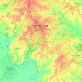
Naam: Topografische kaart College Station, hoogte, reliëf.
Locatie: College Station, Brazos County, Texas, United States (30.51648 -96.38765 30.65841 -96.19656)
Gemiddelde hoogte: 87 m
Minimale hoogte: 55 m
Maximale hoogte: 119 m
Andere topografische kaarten
Klik op een kaart om zijn topografie, zijn hoogte en zijn reliëf te bekijken.
John Crompton Park
United States > Texas > Brazos County > College Station
John Crompton Park, Fox Run Condominiums, College Station, Brazos County, Texas, 77840, United States
Gemiddelde hoogte: 96 m
Bryan
United States > Texas > Brazos County > Bryan
Bryan, Brazos County, Texas, 77803, United States
Gemiddelde hoogte: 89 m
Wixon Valley
United States > Texas > Brazos County
Wixon Valley, Brazos County, Texas, United States
Gemiddelde hoogte: 99 m
College Station
United States > Texas > Brazos County > College Station
College Station, Brazos County, Texas, 77845-5357, United States
Gemiddelde hoogte: 82 m
Moore
United States > Texas > Brazos County > Wixon Valley
Moore, Wixon Valley, Brazos County, Texas, 77808, United States
Gemiddelde hoogte: 101 m
Bryan
United States > Texas > Brazos County
Bryan, Brazos County, Texas, United States
Gemiddelde hoogte: 94 m
Carter Lake
United States > Texas > Brazos County > College Station
Carter Lake, College Station, Brazos County, Texas, United States
Gemiddelde hoogte: 77 m