
Topografische kaart Kent County
Interactieve kaart
Klik op de kaart om de hoogte weer te geven.
Over deze kaart
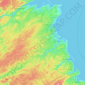
Naam: Topografische kaart Kent County, hoogte, reliëf.
Locatie: Kent County, New Brunswick, Canada (46.25654 -65.84754 47.05743 -64.47498)
Gemiddelde hoogte: 43 m
Minimale hoogte: -4 m
Maximale hoogte: 202 m
Andere topografische kaarten
Klik op een kaart om zijn topografie, zijn hoogte en zijn reliëf te bekijken.
Moncton
Canada > New Brunswick > Moncton
Moncton, Moncton Parish, Westmorland County, New Brunswick, Canada
Gemiddelde hoogte: 52 m
Fundy National Park
Fundy National Park, 114, Albert County, New Brunswick, E4H 1N5, Canada
Gemiddelde hoogte: 230 m
Kouchibouguac National Park
Kouchibouguac National Park, Carleton Parish, New Brunswick, Canada
Gemiddelde hoogte: 17 m
Indian Island
Canada > New Brunswick > Bathurst
Indian Island, Bathurst, Gloucester County, New Brunswick, E2A 1W7, Canada
Gemiddelde hoogte: 97 m
Geologists Range
Geologists Range, Restigouche County, New Brunswick, Canada
Gemiddelde hoogte: 293 m