
Topografische kaart Kwa Sani Local Municipality
Interactieve kaart
Klik op de kaart om de hoogte weer te geven.
Over deze kaart
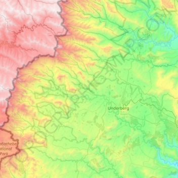
Naam: Topografische kaart Kwa Sani Local Municipality, hoogte, reliëf.
Gemiddelde hoogte: 1.905 m
Minimale hoogte: 1.069 m
Maximale hoogte: 3.415 m
Andere topografische kaarten
Klik op een kaart om zijn topografie, zijn hoogte en zijn reliëf te bekijken.
Himeville
Zuid-Afrika > KwaZoeloe-Natal > Kwa Sani Local Municipality > Himeville
Himeville, Kwa Sani Local Municipality, Sisonke District Municipality, KwaZoeloe-Natal, Zuid-Afrika
Gemiddelde hoogte: 1.535 m