
Topografische kaart Chatham-Kent
Klik op de kaart om de hoogte weer te geven.
Over deze kaart
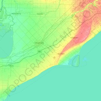
Naam: Topografische kaart Chatham-Kent, hoogte, reliëf.
Locatie: Chatham-Kent, Southwestern Ontario, Ontario, Canada (42.05986 -82.55163 42.65147 -81.62422)
Gemiddelde hoogte: 183 m
Minimale hoogte: 169 m
Maximale hoogte: 232 m
Andere topografische kaarten
Klik op een kaart om zijn topografie, zijn hoogte en zijn reliëf te bekijken.
Toronto
Despite its deep ravines, Toronto is not remarkably hilly, but its elevation does increase steadily away from the lake. Elevation differences range from 76.5 metres (251 ft) above sea level at the Lake Ontario shore to 209 m (686 ft) ASL near the York University grounds in the city's north end at the…
Gemiddelde hoogte: 113 m
London
Canada > Ontario > London > London
London has a humid continental climate (Köppen Dfb), though due to its downwind location relative to Lake Huron and elevation changes across the city, it is virtually on the Dfa/Dfb (hot summer) boundary favouring the former climate zone to the southwest of the confluence of the South and North Thames Rivers,…
Gemiddelde hoogte: 268 m
Guelph
This region of Ontario has cold winters and warm, humid summers, falling into the Köppen climate classification Dfb zone, with moderately high rainfall and snowfall. It is generally a couple of degrees cooler than lower elevation regions on the Great Lakes shorelines, especially so in winter, the exception…
Gemiddelde hoogte: 344 m
Groveton
Canada > Ontario > Leeds and Grenville Counties > Edwardsburgh/Cardinal
Gemiddelde hoogte: 99 m
Shebandowan
Canada > Ontario > Thunder Bay District > Unorganized Thunder Bay District
Gemiddelde hoogte: 461 m
Mount St. Patrick Mountains
Canada > Ontario > Renfrew County > Greater Madawaska
Gemiddelde hoogte: 390 m
Little Crosby Lake
Canada > Ontario > Leeds and Grenville Counties > Rideau Lakes
Gemiddelde hoogte: 166 m
Keswick
Canada > Ontario > York Region
Keswick's geographical coordinates are 44.22°N, 79.45°W, and its elevation above sea level is 221m/762 ft. It has a geographical area of 16.25 km² according to Statistics Canada. It is bound on the north by Roches Point, the east by Woodbine Avenue, the south by East Gwillimbury (Ravenshoe Road) and the…
Gemiddelde hoogte: 228 m
Madawaska River
Canada > Ontario > Renfrew County > Greater Madawaska > Calabogie
Gemiddelde hoogte: 160 m
Peterborough
Canada > Ontario > Peterborough
Peterborough's topography is largely defined by land formations created by the receding Wisconsian glaciers 10,000–15,000 years ago. The South End and Downtown portions of the City sit on what was the bottom of the glacial Lake Peterborough—part of a glacial spillway created when glacial meltwaters from…
Gemiddelde hoogte: 235 m
Burditt Lake
Canada > Ontario > Kenora District > Unorganized Kenora District
Gemiddelde hoogte: 367 m
Manitouwabing Lake
Canada > Ontario > Parry Sound District > McKellar Township > McKellar
Gemiddelde hoogte: 249 m
La Cloche Provincial Park
Canada > Ontario > Sudbury District > Sables-Spanish Rivers Township
Gemiddelde hoogte: 224 m
Kenabeek
Canada > Ontario > Timiskaming District > Unorganized West Timiskaming
Gemiddelde hoogte: 284 m
Foymount
Canada > Ontario > Renfrew County > Bonnechere Valley
The location is also popular for amateur astronomers given the high altitude and low levels of artificial light.
Gemiddelde hoogte: 432 m
Port Loring
Canada > Ontario > Parry Sound District > Unorganized Centre Parry Sound
Gemiddelde hoogte: 227 m
Dundas
Canada > Ontario > Hamilton > Dundas
Dundas /ˈdʌnˌdæs/ is a community and former town in Hamilton, Ontario, Canada. It is nicknamed the Valley Town because of its topographical location at the bottom of the Niagara Escarpment on the western edge of Lake Ontario. The population has been stable for decades at about twenty thousand, largely…
Gemiddelde hoogte: 171 m
Henwood Lake
Canada > Ontario > Timiskaming District > Unorganized West Timiskaming
Gemiddelde hoogte: 288 m
Sulphur Lake
Canada > Ontario > Thunder Bay District > Unorganized Thunder Bay District
Gemiddelde hoogte: 467 m