
Topografische kaart Guelph
Interactieve kaart
Klik op de kaart om de hoogte weer te geven.
Over deze kaart
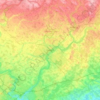
Naam: Topografische kaart Guelph, hoogte, reliëf.
Locatie: Guelph, Southwestern Ontario, Ontario, N1H 4E7, Canada (43.38605 -80.40933 43.70605 -80.08933)
Gemiddelde hoogte: 344 m
Minimale hoogte: 267 m
Maximale hoogte: 440 m
This region of Ontario has cold winters and warm, humid summers, falling into the Köppen climate classification Dfb zone, with moderately high rainfall and snowfall. It is generally a couple of degrees cooler than lower elevation regions on the Great Lakes shorelines, especially so in winter, the exception being on some spring afternoons when the lack of an onshore breeze boosts temperatures well above those found lakeside.
Andere topografische kaarten
Klik op een kaart om zijn topografie, zijn hoogte en zijn reliëf te bekijken.
John Gamble Park
John Gamble Park, Hanlon Creek, Guelph, Ontario, Canada
Gemiddelde hoogte: 327 m
The Arboretum
The Arboretum, Guelph, Southwestern Ontario, Ontario, Canada
Gemiddelde hoogte: 332 m
Silver Creek Conservation Area
Silver Creek Conservation Area, The Ward, Guelph, Southwestern Ontario, Ontario, N1E 3E9, Canada
Gemiddelde hoogte: 326 m