
Topografische kaart Mayagüez
Interactieve kaart
Klik op de kaart om de hoogte weer te geven.
Over deze kaart
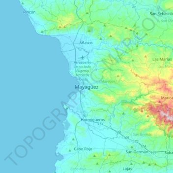
Naam: Topografische kaart Mayagüez, hoogte, reliëf.
Locatie: Mayagüez, Puerto Rico, 00680, United States (18.04112 -67.29911 18.36112 -66.97911)
Gemiddelde hoogte: 93 m
Minimale hoogte: 0 m
Maximale hoogte: 878 m
Mayagüez has a tropical monsoon climate (Köppen climate classification Am). The city has the most extreme weather of the island. The high frequency of severe storms in the summer can produce strong winds, floods, waterspouts, and sometimes hail and even tornadoes. The average annual temperature is 75 °F (24 °C). Winter is usually quite dry and cool, with temperatures between 82 °F (28 °C) and 55 °F (13 °C). Summer is usually very hot and humid, with temperatures reaching 95 °F (35 °C), with heat index of up to 115 °F. From May to October, most evenings experience severe thunderstorms, due to heat, humidity and the topography of the area.
Andere topografische kaarten
Klik op een kaart om zijn topografie, zijn hoogte en zijn reliëf te bekijken.
Isla de Mona e Islote Monito
United States > Puerto Rico > Mayagüez
Isla de Mona e Islote Monito, Mayagüez, Puerto Rico, United States
Gemiddelde hoogte: 20 m