
Topografische kaart Saint John
Interactieve kaart
Klik op de kaart om de hoogte weer te geven.
Over deze kaart
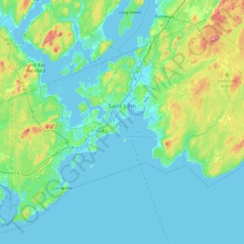
Naam: Topografische kaart Saint John, hoogte, reliëf.
Locatie: Saint John, Saint John County, New Brunswick, Canada (45.14150 -66.23940 45.37693 -65.83886)
Gemiddelde hoogte: 39 m
Minimale hoogte: -8 m
Maximale hoogte: 223 m
Andere topografische kaarten
Klik op een kaart om zijn topografie, zijn hoogte en zijn reliëf te bekijken.
Saint John
Canada > New Brunswick > Saint John
Saint John, City of Saint John, Saint John County, New Brunswick, E2L 3L6, Canada
Gemiddelde hoogte: 44 m
Reversing Falls
Canada > New Brunswick > Saint John
Reversing Falls, City of Saint John, Saint John County, New Brunswick, E2M 3N4, Canada
Gemiddelde hoogte: 20 m
Saint John Harbour
Canada > New Brunswick > Saint John
Saint John Harbour, Old Red Head Road, Red Head, Black River Road, Saint John, City of Saint John, Saint John County, New Brunswick, E2J 1N8, Canada
Gemiddelde hoogte: 0 m
Quinn Lake
Canada > New Brunswick > Saint John
Quinn Lake, Golden Grove Road, Saint John, City of Saint John, Saint John County, New Brunswick, E2J 2S6, Canada
Gemiddelde hoogte: 79 m
Robertson Lake
Canada > New Brunswick > Saint John
Robertson Lake, Loch Lomond Road, Saint John, Saint John County, New Brunswick, E2N 1C6, Canada
Gemiddelde hoogte: 103 m