
Topografische kaart Newry
Interactieve kaart
Klik op de kaart om de hoogte weer te geven.
Over deze kaart
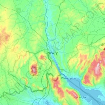
Naam: Topografische kaart Newry, hoogte, reliëf.
Locatie: Newry, County Down, Northern Ireland, BT35 6BH, United Kingdom (54.01753 -6.49751 54.33753 -6.17751)
Gemiddelde hoogte: 129 m
Minimale hoogte: -1 m
Maximale hoogte: 632 m
Andere topografische kaarten
Klik op een kaart om zijn topografie, zijn hoogte en zijn reliëf te bekijken.
Mourne Mountains West
United Kingdom > Northern Ireland > Newry
Mourne Mountains West, Newry, County Down, Northern Ireland, United Kingdom
Gemiddelde hoogte: 272 m
Ballyholland Lower
United Kingdom > Northern Ireland > Newry
Ballyholland Lower, Newry, County Down, Northern Ireland, United Kingdom
Gemiddelde hoogte: 60 m
Lisdrumgullion
United Kingdom > Northern Ireland > Newry
Lisdrumgullion, Newry, County Down, Northern Ireland, BT35 6BH, United Kingdom
Gemiddelde hoogte: 41 m