
Topografische kaart Gabriola Island
Interactieve kaart
Klik op de kaart om de hoogte weer te geven.
Over deze kaart
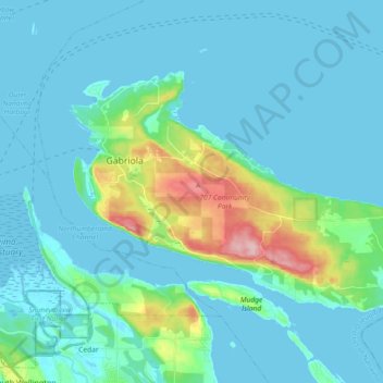
Naam: Topografische kaart Gabriola Island, hoogte, reliëf.
Gemiddelde hoogte: 26 m
Minimale hoogte: -2 m
Maximale hoogte: 174 m
Gabriola is about 14 kilometres (9 mi) long by 4.2 kilometres (2.6 mi) wide on average with a land area of 57.6 square kilometres (22.2 sq mi). The topography varies from flat sandy beaches at sea level to forested hills rising to 160 metres (525 ft) on Stoney Ridge in the centre of the island.
Andere topografische kaarten
Klik op een kaart om zijn topografie, zijn hoogte en zijn reliëf te bekijken.
Gaviola Island
Canada > British Columbia > Regional District of Nanaimo > Area B (DeCourcy/Gabriola/Mudge)
Gaviola Island, Area B (DeCourcy/Gabriola/Mudge), Regional District of Nanaimo, British Columbia, Canada
Gemiddelde hoogte: 3 m
Gabriola
Canada > British Columbia > Regional District of Nanaimo > Area B (DeCourcy/Gabriola/Mudge)
Gabriola, Area B (DeCourcy/Gabriola/Mudge), Regional District of Nanaimo, British Columbia, V0R 1X6, Canada
Gemiddelde hoogte: 31 m