Geolokaliseren

Topografische kaart Collin County

Interactieve kaart

Klik op de kaart om de hoogte weer te geven.

Over deze kaart

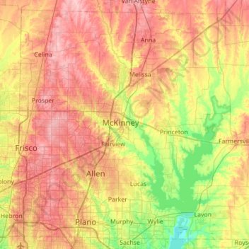
Naam: Topografische kaart Collin County, hoogte, reliëf.

Locatie: Collin County, Texas, United States (32.98150 -96.84413 33.40548 -96.29535)

Gemiddelde hoogte: 191 m

Minimale hoogte: 131 m

Maximale hoogte: 252 m

Andere topografische kaarten

Klik op een kaart om zijn topografie, zijn hoogte en zijn reliëf te bekijken.

Georgetown

United States > Texas > Georgetown

The city is located on the northeastern edge of Texas Hill Country. Portions of Georgetown are located on either side of the Balcones Escarpment, a fault line in which the areas roughly east of IH-35 are flat and characterized by having black, fertile soils of the Blackland Prairie, and the west side of the…

Gemiddelde hoogte: 219 m

San Antonio

United States > Texas > Bexar County > San Antonio

Gemiddelde hoogte: 218 m

Sprinkle Corner

United States > Texas > Travis County > Austin

Gemiddelde hoogte: 202 m

Prinston

United States > Texas > Navarro County > Corsicana

Gemiddelde hoogte: 144 m

Gruene

United States > Texas > Comal County > New Braunfels

Gemiddelde hoogte: 210 m

Fair Oaks

United States > Texas > Limestone County

Gemiddelde hoogte: 130 m

Turkey Creek

United States > Texas > Travis County > Austin

Gemiddelde hoogte: 198 m

Cypress

United States > Texas > Harris County

Gemiddelde hoogte: 46 m

Schwab City

United States > Texas > Polk County

Gemiddelde hoogte: 66 m

Fort Hancock

United States > Texas > Hudspeth County

Gemiddelde hoogte: 1.094 m

Bacliff

United States > Texas > Galveston County

After Hurricane Ike hit Texas in September 2008, Galveston County officials offered a debris removal program to residents in unincorporated areas, including Bacliff. Flooding from hurricane Ike was minimized due in part to Bacliff's relatively high elevation of 16 feet.

Gemiddelde hoogte: 4 m

Colfax

United States > Texas > Van Zandt County

Gemiddelde hoogte: 170 m

Peaster

United States > Texas > Parker County

Gemiddelde hoogte: 367 m

Union

United States > Texas > Brazos County

Gemiddelde hoogte: 97 m

Emory Peak

United States > Texas > Brewster County

The peak can be reached by a moderate hike on a well-marked path across steep rocky terrain with an elevation gain of approximately 2,500 feet (760 m). The Emory Peak Trail is about 1.5 miles (2.4 km) long. The trail is reached by climbing the Pinnacles Trail 3.5 miles (5.6 km) from the Chisos Basin trailhead.…

Gemiddelde hoogte: 2.061 m

Hills of Roanoke

United States > Texas > Denton County > Roanoke

Gemiddelde hoogte: 180 m

Cookville

United States > Texas > Titus County

Gemiddelde hoogte: 128 m

Spring

United States > Texas > Harris County

Gemiddelde hoogte: 35 m

South Point

United States > Texas > Cameron County

Gemiddelde hoogte: 7 m

Fourmile Crossing

United States > Texas > Menard County

Gemiddelde hoogte: 606 m

Startzville

United States > Texas > Comal County

Gemiddelde hoogte: 333 m

Damon

United States > Texas > Brazoria County

Gemiddelde hoogte: 25 m

Oak Grove

United States > Texas > San Jacinto County

Gemiddelde hoogte: 70 m

Kleberg

United States > Texas > Dallas County > Dallas

Gemiddelde hoogte: 129 m

Montague

United States > Texas > Montague County

Gemiddelde hoogte: 326 m

Farnsworth

United States > Texas > Ochiltree County

Farnsworth is a census designated place in western Ochiltree County, Texas, United States. It lies at the intersection of State Highway 15 with FM376, southwest of the city of Perryton, the county seat of Ochiltree County. Its elevation is 2,995 feet (913 m). Although Farnsworth is unincorporated, it has a…

Gemiddelde hoogte: 913 m

Centerville

United States > Texas > Dallas County > Garland

Gemiddelde hoogte: 159 m

Paynes

United States > Texas > Fort Bend County > Sugar Land

Gemiddelde hoogte: 24 m

Pluck

United States > Texas > Polk County

Gemiddelde hoogte: 61 m

Woodland

United States > Texas > Bell County > Temple

Gemiddelde hoogte: 191 m

Eylau

United States > Texas > Bowie County

Gemiddelde hoogte: 93 m

Altoga

United States > Texas > Collin County

Gemiddelde hoogte: 176 m

McCook

United States > Texas > Hidalgo County

Gemiddelde hoogte: 96 m

Mount Herman

United States > Texas > Shelby County

Gemiddelde hoogte: 124 m

Terlingua

United States > Texas > Brewster County

Gemiddelde hoogte: 872 m

Clear Lake

United States > Texas > Collin County

Gemiddelde hoogte: 157 m

Cline

United States > Texas > Uvalde County

Gemiddelde hoogte: 311 m

Sharp

United States > Texas > Milam County

Gemiddelde hoogte: 141 m

Union Center

United States > Texas > Eastland County

Gemiddelde hoogte: 489 m

Buncome

United States > Texas > Panola County

Gemiddelde hoogte: 85 m

Ravenna

United States > Texas > Fannin County > Ravenna

Gemiddelde hoogte: 177 m

Pease River

United States > Texas > Wilbarger County

Gemiddelde hoogte: 382 m

Olden

United States > Texas > Eastland County

Gemiddelde hoogte: 472 m

Padre Island

United States > Texas > Kenedy County

Gemiddelde hoogte: 3 m

Citrus City

United States > Texas > Hidalgo County

Gemiddelde hoogte: 67 m

Sandstone Mountain

United States > Texas > Llano County

Gemiddelde hoogte: 339 m

Laguna Vista

United States > Texas > Burnet County

Gemiddelde hoogte: 297 m

Bend

United States > Texas > San Saba County

Gemiddelde hoogte: 350 m

Chappell Hill

United States > Texas > Washington County

Gemiddelde hoogte: 83 m

Spring

United States > Texas

Gemiddelde hoogte: 35 m

Maryneal

United States > Texas > Nolan County

Gemiddelde hoogte: 780 m

Bel Air

United States > Texas > Harrison County > Marshall

Gemiddelde hoogte: 120 m

Casa Piedra

United States > Texas > Presidio County

Gemiddelde hoogte: 1.056 m

Mount Zion

United States > Texas > Montgomery County

Gemiddelde hoogte: 88 m

Dupree Park

United States > Texas > Lubbock County > Lubbock

Gemiddelde hoogte: 993 m

San Luis Pass

United States > Texas > Galveston County > Galveston

Tides cause daily variations in topography, and occasionally, storms more drastically change the topography of the pass.

Gemiddelde hoogte: 0 m

Cedar Creek

United States > Texas > Bastrop County

Gemiddelde hoogte: 125 m

Cedar Bayou

United States > Texas > Harris County > Baytown

Gemiddelde hoogte: 9 m

Muldoon

United States > Texas > Fayette County

Gemiddelde hoogte: 104 m

Kingsland

United States > Texas > Llano County

Gemiddelde hoogte: 272 m

Zacha Junction

United States > Texas > Dallas County > Dallas

Gemiddelde hoogte: 176 m

Spring

United States > Texas > Harris County

Gemiddelde hoogte: 35 m

Cason

United States > Texas > Morris County

Gemiddelde hoogte: 97 m

Bentsen Colonia

United States > Texas > Hidalgo County > McAllen

Gemiddelde hoogte: 38 m

Peoria

United States > Texas > Hill County

Gemiddelde hoogte: 191 m

Marjorie

United States > Texas > Milam County

Gemiddelde hoogte: 148 m

Lolita

United States > Texas > Jackson County

Gemiddelde hoogte: 12 m

Snake Forest

United States > Texas > Parker County

Gemiddelde hoogte: 312 m

Carol Colonia

United States > Texas > Hidalgo County

Gemiddelde hoogte: 59 m

Brazos Bend State Park

United States > Texas > Fort Bend County > Alvin

Brazos Bend State Park occupies land bordering the Brazos River and includes within its boundaries low-lying areas left over from the River's previous meanderings. Pre-Columbian inhabitants included a series of Native American groups, most notably the Karankawa. The land passed through a variety of landowners'…

Gemiddelde hoogte: 17 m

Memorial Park

United States > Texas > Harris County > Houston

Gemiddelde hoogte: 21 m

Ottine

United States > Texas > Gonzales County

Gemiddelde hoogte: 104 m

Sierra Blanca

United States > Texas > Hudspeth County

Sierra Blanca is found in Far West Texas, a subdivision of West Texas, and is 4,520 feet (1,380 m) above sea level. The town is part of the Trans-Pecos region within the most mountainous and arid portion of Texas. The town is located in Hudspeth County, which is large and sparsely populated. Sierra Blanca…

Gemiddelde hoogte: 1.391 m

Biel Lake

United States > Texas > Webb County

Gemiddelde hoogte: 116 m

East Delta

United States > Texas > Delta County

Gemiddelde hoogte: 128 m

Atascocita

United States > Texas > Harris County

Gemiddelde hoogte: 19 m

Mc Arthur Park

United States > Texas > El Paso County > El Paso > Cielo Vista

Gemiddelde hoogte: 1.199 m

Elm Mott

United States > Texas > McLennan County

Gemiddelde hoogte: 156 m

Ruidosa

United States > Texas > Presidio County

Gemiddelde hoogte: 865 m

Marathon

United States > Texas > Brewster County

Gemiddelde hoogte: 1.244 m

Preiss Heights

United States > Texas > Comal County

Gemiddelde hoogte: 214 m

Santo

United States > Texas > Palo Pinto County

Gemiddelde hoogte: 264 m