
Topografische kaart Kingsville
Interactieve kaart
Klik op de kaart om de hoogte weer te geven.
Over deze kaart
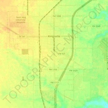
Naam: Topografische kaart Kingsville, hoogte, reliëf.
Locatie: Kingsville, Kleberg County, Texas, 78363, United States (27.46295 -97.89506 27.54248 -97.82856)
Gemiddelde hoogte: 19 m
Minimale hoogte: 2 m
Maximale hoogte: 27 m
Kingsville is located in the historic Wild Horse Desert, an area of South Texas and northern Mexico where enormous herds of wild mustangs roamed. Due to water pumping and other environmental factors, the abundance of spring-fed creeks has decreased. Wildlife surrounding Kingsville include deer, wild turkey, and javelinas. Additionally, Kingsville is a winter home to a large number of waterfowl species, including geese, ducks, and pelicans. The city is surrounded by farmland producing various crops including cotton and sorghum. The terrain around Kingsville is generally flat, with an elevation of 59 feet above sea level at city center.
Andere topografische kaarten
Klik op een kaart om zijn topografie, zijn hoogte en zijn reliëf te bekijken.
Padre Island National Seashore
United States > Texas > Kleberg County
Padre Island National Seashore, 20301, Park Road 22, Kleberg County, Texas, 78418, United States
Gemiddelde hoogte: 5 m