Geolokaliseren

Topografische kaart Middletown

Interactieve kaart

Klik op de kaart om de hoogte weer te geven.

Over deze kaart

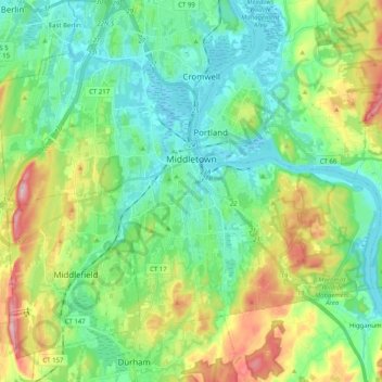
Naam: Topografische kaart Middletown, hoogte, reliëf.

Locatie: Middletown, Lower Connecticut River Valley Planning Region, Connecticut, United States (41.49484 -72.75294 41.60432 -72.55095)

Gemiddelde hoogte: 76 m

Minimale hoogte: -2 m

Maximale hoogte: 262 m

Andere topografische kaarten

Klik op een kaart om zijn topografie, zijn hoogte en zijn reliëf te bekijken.

Clinton

United States > Connecticut > Lower Connecticut River Valley Planning Region

Clinton, Lower Connecticut River Valley Planning Region, Connecticut, 06413, United States

Gemiddelde hoogte: 27 m

Field Park

United States > Connecticut > Lower Connecticut River Valley Planning Region > Middletown > Newfield Heights

Field Park, Newfield Heights, Middletown, Lower Connecticut River Valley Planning Region, Connecticut, United States

Gemiddelde hoogte: 39 m

Westbrook Center

United States > Connecticut > Lower Connecticut River Valley Planning Region > Westbrook

Westbrook Center, Westbrook, Lower Connecticut River Valley Planning Region, Connecticut, United States

Gemiddelde hoogte: 7 m

Essex Village

United States > Connecticut > Lower Connecticut River Valley Planning Region > Essex

Essex Village, Essex, Lower Connecticut River Valley Planning Region, Connecticut, United States

Gemiddelde hoogte: 22 m

Lake Pocotopaug

United States > Connecticut > Lower Connecticut River Valley Planning Region > East Hampton

Lake Pocotopaug, East Hampton, Lower Connecticut River Valley Planning Region, Connecticut, 06424, United States

Gemiddelde hoogte: 184 m

Chester Center

United States > Connecticut > Lower Connecticut River Valley Planning Region > Chester

Chester Center, Chester, Lower Connecticut River Valley Planning Region, Connecticut, 06412, United States

Gemiddelde hoogte: 52 m

Oxford Park

United States > Connecticut > Lower Connecticut River Valley Planning Region > Cromwell

Oxford Park, Cromwell, Lower Connecticut River Valley Planning Region, Connecticut, 06416, United States

Gemiddelde hoogte: 32 m

Johnsonville

United States > Connecticut > Lower Connecticut River Valley Planning Region > East Haddam > Moodus

Johnsonville, Moodus, East Haddam, Lower Connecticut River Valley Planning Region, Connecticut, 06469, United States

Gemiddelde hoogte: 58 m

Old Lyme

United States > Connecticut > Lower Connecticut River Valley Planning Region

Old Lyme, Lower Connecticut River Valley Planning Region, Connecticut, United States

Gemiddelde hoogte: 19 m

Pond Meadow

United States > Connecticut > Lower Connecticut River Valley Planning Region > Westbrook

Pond Meadow, Westbrook, Lower Connecticut River Valley Planning Region, Connecticut, 06442, United States

Gemiddelde hoogte: 53 m

Pocotopaug Lake

United States > Connecticut > Lower Connecticut River Valley Planning Region > East Hampton > Lake Pocotopaug

Pocotopaug Lake, Lake Pocotopaug, East Hampton, Lower Connecticut River Valley Planning Region, Connecticut, United States

Gemiddelde hoogte: 156 m

Clinton

United States > Connecticut > Lower Connecticut River Valley Planning Region > Clinton

Clinton, Lower Connecticut River Valley Planning Region, Connecticut, United States

Gemiddelde hoogte: 7 m

East Hampton

United States > Connecticut > Lower Connecticut River Valley Planning Region

East Hampton, Lower Connecticut River Valley Planning Region, Connecticut, United States

Gemiddelde hoogte: 129 m

Middlesex County

United States > Connecticut > Lower Connecticut River Valley Planning Region

Middlesex County, Lower Connecticut River Valley Planning Region, Connecticut, United States

Gemiddelde hoogte: 81 m

Old Saybrook

United States > Connecticut > Lower Connecticut River Valley Planning Region

Old Saybrook, Lower Connecticut River Valley Planning Region, Connecticut, 06475, United States

Gemiddelde hoogte: 11 m

East Haddam

United States > Connecticut > Lower Connecticut River Valley Planning Region

East Haddam, Lower Connecticut River Valley Planning Region, Connecticut, United States

Gemiddelde hoogte: 96 m

Cromwell

United States > Connecticut > Lower Connecticut River Valley Planning Region

Cromwell, Lower Connecticut River Valley Planning Region, Connecticut, 06416, United States

Gemiddelde hoogte: 30 m

Durham

United States > Connecticut > Lower Connecticut River Valley Planning Region

Durham, Lower Connecticut River Valley Planning Region, Connecticut, 06422, United States

Gemiddelde hoogte: 121 m

Haddam

United States > Connecticut > Lower Connecticut River Valley Planning Region

Haddam, Lower Connecticut River Valley Planning Region, Connecticut, United States

Gemiddelde hoogte: 96 m

Westbrook

United States > Connecticut > Lower Connecticut River Valley Planning Region

Westbrook, Lower Connecticut River Valley Planning Region, Connecticut, 06498, United States

Gemiddelde hoogte: 24 m

Killingworth

United States > Connecticut > Lower Connecticut River Valley Planning Region

Killingworth, Lower Connecticut River Valley Planning Region, Connecticut, 06419, United States

Gemiddelde hoogte: 102 m

Lyme

United States > Connecticut > Lower Connecticut River Valley Planning Region

Lyme, Lower Connecticut River Valley Planning Region, Connecticut, United States

Gemiddelde hoogte: 49 m