
Topografische kaart Ilmenau
Interactieve kaart
Klik op de kaart om de hoogte weer te geven.
Over deze kaart
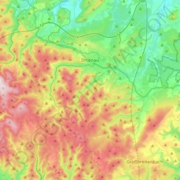
Naam: Topografische kaart Ilmenau, hoogte, reliëf.
Locatie: Ilmenau, Ilm-Kreis, Thuringia, Germany (50.56143 10.81823 50.74946 11.06661)
Gemiddelde hoogte: 604 m
Minimale hoogte: 364 m
Maximale hoogte: 965 m
Ilmenau (German pronunciation: [ˈɪlmənaʊ̯] (listen)) is a town in Thuringia, central Germany. It is the largest town within the Ilm district with a population of 38,600, while the district capital is Arnstadt. Ilmenau is located approximately 33 km (21 miles) south of Erfurt and 135 km (84 miles) north of Nuremberg within the Ilm valley at the northern edge of the Thuringian Forest at an elevation of 500 metres (1,640 feet).
Andere topografische kaarten
Klik op een kaart om zijn topografie, zijn hoogte en zijn reliëf te bekijken.
Großbreitenbach
Germany > Thuringia > Ilm-Kreis > Großbreitenbach
Großbreitenbach, Ilm-Kreis, Thuringia, Germany
Gemiddelde hoogte: 596 m
Burg Ehrenstein
Germany > Thuringia > Ilm-Kreis > Stadtilm > Ehrenstein
Burg Ehrenstein, Ehrenstein, Stadtilm, Ilm-Kreis, Thuringia, 99326, Germany
Gemiddelde hoogte: 415 m