
Topografische kaart Rajpura
Interactieve kaart
Klik op de kaart om de hoogte weer te geven.
Over deze kaart
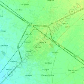
Naam: Topografische kaart Rajpura, hoogte, reliëf.
Locatie: Rajpura, Rajpura Tahsil, Patiala, Punjab, 140401, India (30.43769 76.55377 30.51769 76.63377)
Gemiddelde hoogte: 270 m
Minimale hoogte: 263 m
Maximale hoogte: 277 m
Rajpura is located at 30°29′N 76°36′E / 30.48°N 76.6°E / 30.48; 76.6. It has an average elevation of 259 metres (849 feet). Rajpura is situated nearly 38 km south west of Chandigarh, the capital city of Punjab. Besides being an important industrial town of Punjab, it also has historical importance.