
Topografische kaart Wadley
Interactieve kaart
Klik op de kaart om de hoogte weer te geven.
Over deze kaart
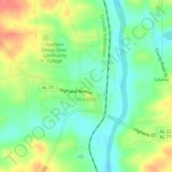
Naam: Topografische kaart Wadley, hoogte, reliëf.
Locatie: Wadley, Randolph County, Alabama, United States (33.11254 -85.58059 33.13446 -85.55075)
Gemiddelde hoogte: 209 m
Minimale hoogte: 183 m
Maximale hoogte: 247 m
Andere topografische kaarten
Klik op een kaart om zijn topografie, zijn hoogte en zijn reliëf te bekijken.
Wedowee Club Lake Dam
United States > Alabama > Randolph County
Wedowee Club Lake Dam, Randolph County, Alabama, United States
Gemiddelde hoogte: 280 m
Wedowee
United States > Alabama > Randolph County
Wedowee, Randolph County, Alabama, United States
Gemiddelde hoogte: 278 m
Roanoke
United States > Alabama > Randolph County
Roanoke, Randolph County, Alabama, 36274, United States
Gemiddelde hoogte: 252 m
High Pine
United States > Alabama > Randolph County
High Pine, Randolph County, Alabama, United States
Gemiddelde hoogte: 235 m
Flat Rock
United States > Alabama > Randolph County
Flat Rock, Randolph County, Alabama, United States
Gemiddelde hoogte: 253 m
Melody Lane
United States > Alabama > Randolph County > Roanoke
Melody Lane, Roanoke, Randolph County, Alabama, 36274, United States
Gemiddelde hoogte: 262 m
Woodland
United States > Alabama > Randolph County
Woodland, Randolph County, Alabama, 36280, United States
Gemiddelde hoogte: 313 m
Newell
United States > Alabama > Randolph County > Newell
Newell, Randolph County, Alabama, 36270, United States
Gemiddelde hoogte: 286 m
Roanoke
United States > Alabama > Randolph County > Roanoke
Roanoke, Randolph County, Alabama, 36274, United States
Gemiddelde hoogte: 251 m