
Doe een donatie
Rust jezelf uit voor je volgende avontuur:
Als Amazon-partner verdient deze site een commissie op in aanmerking komende aankopen, zonder extra kosten voor jou.
Topografische kaart Surquillo
Klik op de kaart om de hoogte weer te geven.
Doe een donatie
Rust jezelf uit voor je volgende avontuur:
Als Amazon-partner verdient deze site een commissie op in aanmerking komende aankopen, zonder extra kosten voor jou.
Surquillo
Since the beginning of the 2000s and the beginning of the 2010s, and to a greater extent today, there has been a considerable real estate boom within Surquillo, in which many residential real estate companies have invested in new residential building projects in several points of the district due to the modification of the urban and building parameters in the district. For this reason, many high-altitude residential buildings have been built in different points such as the areas adjacent to Principal and Andrés Aramburú avenues, as well as parts of urbanizations such as La Calera, Barrio Médico, Los Sauces, and recently along the route of Tomás Marsano Avenue on the border with the Miraflores district and sections of Angamos Avenue. This also brought about the appreciation of house prices in various parts of the district.
Doe een donatie
Rust jezelf uit voor je volgende avontuur:
Als Amazon-partner verdient deze site een commissie op in aanmerking komende aankopen, zonder extra kosten voor jou.
Over deze kaart
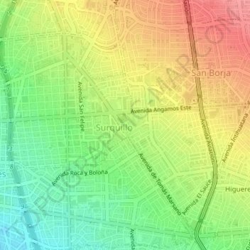
Naam: Topografische kaart Surquillo, hoogte, reliëf.
Gemiddelde hoogte: 118 m
Minimale hoogte: 78 m
Maximale hoogte: 163 m
Doe een donatie
Rust jezelf uit voor je volgende avontuur:
Als Amazon-partner verdient deze site een commissie op in aanmerking komende aankopen, zonder extra kosten voor jou.