
Topografische kaart Lake Of The Ozarks
Interactieve kaart
Klik op de kaart om de hoogte weer te geven.
Over deze kaart
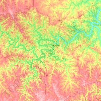
Naam: Topografische kaart Lake Of The Ozarks, hoogte, reliëf.
Gemiddelde hoogte: 265 m
Minimale hoogte: 163 m
Maximale hoogte: 381 m
The lake was created by the construction of the 2,543-foot (775 m) long Bagnell Dam by the Union Electric Company of St. Louis, Missouri. The principal engineering firm was Stone and Webster. Construction began August 8, 1929, was completed in April 1931 and reached spillway elevation on May 20, 1931. During construction, the lake was referred to as Osage Reservoir or Lake Osage. The Missouri General Assembly officially named it Lake Benton after Senator Thomas Hart Benton. None of the names stuck, as it was popularly referred to by its location at the northern edge of the Ozarks. The electric generating station, however, is still referred to by the utility company as the "Osage Hydroelectric Plant." While some sources indicate that more than 20 towns, villages and settlements were permanently flooded to create the lake, subsequent research indicates that the actual number was closer to eight, while several other sites had been previously abandoned, were relocated to make way for the lake, or were on high enough ground that the creation of the lake did not affect them.
Andere topografische kaarten
Klik op een kaart om zijn topografie, zijn hoogte en zijn reliëf te bekijken.
Fort Leonard Wood
United States of America > Missouri > Fort Leonard Wood
Fort Leonard Wood, Pulaski County, Missouri, 65473, United States of America
Gemiddelde hoogte: 318 m
California
United States of America > Missouri > California
California, Moniteau County, Missouri, 65018, United States of America
Gemiddelde hoogte: 254 m
Dr. Edmund A. Babler Memorial State Park
United States of America > Missouri > Wildwood > Centaur
Dr. Edmund A. Babler Memorial State Park, Hillside Drive, Centaur, Wildwood, Saint Louis County, Missouri, 63005, United States of America
Gemiddelde hoogte: 187 m
Louisiana
United States of America > Missouri > Louisiana
Louisiana, Pike County, Missouri, 63353, United States of America
Gemiddelde hoogte: 165 m
Gasconade County
United States of America > Missouri
Gasconade County, Missouri, United States of America
Gemiddelde hoogte: 230 m
Battlefield
United States of America > Missouri > Battlefield
Battlefield, Greene County, Missouri, United States of America
Gemiddelde hoogte: 379 m
Gatewood
United States of America > Missouri > Gatewood
Gatewood, Ripley County, Missouri, United States of America
Gemiddelde hoogte: 187 m
Creve Coeur
United States of America > Missouri > Creve Coeur
Creve Coeur, Saint Louis County, Missouri, 63141, United States of America
Gemiddelde hoogte: 179 m
Manchester
United States of America > Missouri > Manchester
Manchester, Saint Louis County, Missouri, United States of America
Gemiddelde hoogte: 170 m
Thayer
United States of America > Missouri > Thayer
Thayer, Oregon County, Missouri, 65791, United States of America
Gemiddelde hoogte: 188 m
Scotsdale
United States of America > Missouri > Scotsdale
Scotsdale, Jefferson County, Missouri, United States of America
Gemiddelde hoogte: 196 m
Lockwood
United States of America > Missouri > Lockwood
Lockwood, Dade County, Missouri, 65682, United States of America
Gemiddelde hoogte: 330 m
Toonerville
United States of America > Missouri > Toonerville
Toonerville, Saint Charles County, Missouri, United States of America
Gemiddelde hoogte: 190 m
Hutchison
United States of America > Missouri > Hutchison
Hutchison, Ralls County, Missouri, United States of America
Gemiddelde hoogte: 226 m
Eagleville
United States of America > Missouri > Eagleville
Eagleville, Harrison County, Missouri, United States of America
Gemiddelde hoogte: 325 m
Oakville
United States of America > Missouri > Oakville
Oakville, Saint Louis County, Missouri, 63129, United States of America
Gemiddelde hoogte: 139 m
Davisville
United States of America > Missouri > Davisville
Davisville, Crawford County, Missouri, 65456, United States of America
Gemiddelde hoogte: 287 m
Expansion
United States of America > Missouri > Expansion
Expansion, Greene County, Missouri, 65809, United States of America
Gemiddelde hoogte: 391 m
Rington
United States of America > Missouri > Rington
Rington, Dunklin County, Missouri, 72438:72442, United States of America
Gemiddelde hoogte: 73 m
Pilot Knob
United States of America > Missouri > Pilot Knob
Pilot Knob, Iron County, Missouri, 63663, United States of America
Gemiddelde hoogte: 334 m
Raytown
United States of America > Missouri > Raytown
Raytown, Jackson County, Missouri, United States of America
Gemiddelde hoogte: 289 m
Versailles
United States of America > Missouri > Versailles
Versailles, Morgan County, Missouri, United States of America
Gemiddelde hoogte: 299 m
Lowndes
United States of America > Missouri > Lowndes
Lowndes, Wayne County, Missouri, United States of America
Gemiddelde hoogte: 158 m
Mackenzie
United States of America > Missouri > Mackenzie > Mackenzie
Mackenzie, Saint Louis County, Missouri, 34324, United States of America
Gemiddelde hoogte: 149 m
Grantwood
United States of America > Missouri > Grantwood
Grantwood, Saint Louis County, Missouri, 63123-3935, United States of America
Gemiddelde hoogte: 171 m
Shady Valley
United States of America > Missouri > Shady Valley
Shady Valley, Jefferson County, Missouri, United States of America
Gemiddelde hoogte: 232 m