
Topografische kaart Huntingburg
Interactieve kaart
Klik op de kaart om de hoogte weer te geven.
Over deze kaart
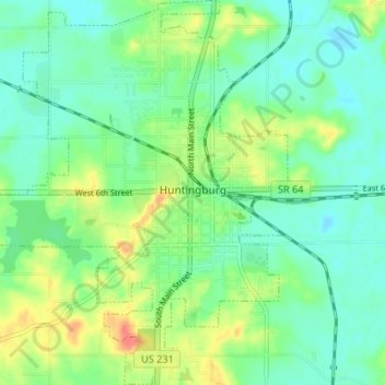
Naam: Topografische kaart Huntingburg, hoogte, reliëf.
Locatie: Huntingburg, Dubois County, Indiana, 47542, United States (38.27276 -86.98886 38.32437 -86.93784)
Gemiddelde hoogte: 148 m
Minimale hoogte: 130 m
Maximale hoogte: 187 m
Andere topografische kaarten
Klik op een kaart om zijn topografie, zijn hoogte en zijn reliëf te bekijken.
Hillham
United States > Indiana > Dubois County
Hillham, Dubois County, Indiana, United States
Gemiddelde hoogte: 208 m
Celestine
United States > Indiana > Dubois County
Celestine, Dubois County, Indiana, 47580, United States
Gemiddelde hoogte: 185 m
Jasper
United States > Indiana > Dubois County > Jasper
Jasper, Dubois County, Indiana, 47546, United States
Gemiddelde hoogte: 150 m
Holland
United States > Indiana > Dubois County > Holland
Holland, Dubois County, Indiana, United States
Gemiddelde hoogte: 155 m
Jasper
United States > Indiana > Dubois County > Jasper
Jasper, Dubois County, Indiana, United States
Gemiddelde hoogte: 151 m
Ferdinand
United States > Indiana > Dubois County
Ferdinand, Dubois County, Indiana, 47532, United States
Gemiddelde hoogte: 162 m