
Topografische kaart Ketchikan
Interactieve kaart
Klik op de kaart om de hoogte weer te geven.
Ketchikan
Due to its steep and forested terrain, Ketchikan is long and narrow with much of the built-up area being located along, or no more than a few city blocks from, the waterfront. Elevations of inhabited areas range from just above sea level to about 300 feet (91 m). Deer Mountain, a 3,001-foot (915 m) peak, rises immediately east of the city's downtown area.
Over deze kaart
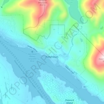
Naam: Topografische kaart Ketchikan, hoogte, reliëf.
Locatie: Ketchikan, Ketchikan Gateway, Alaska, 99901, United States (55.32653 -131.70734 55.36437 -131.61494)
Gemiddelde hoogte: 149 m
Minimale hoogte: -2 m
Maximale hoogte: 848 m