
Topografische kaart Barrie Island
Interactieve kaart
Klik op de kaart om de hoogte weer te geven.
Over deze kaart
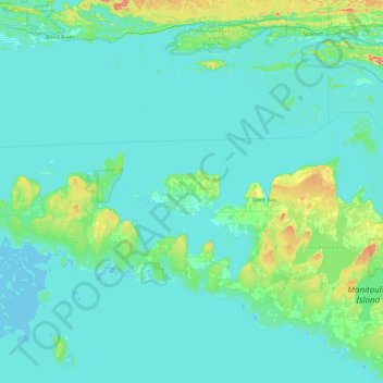
Naam: Topografische kaart Barrie Island, hoogte, reliëf.
Gemiddelde hoogte: 189 m
Minimale hoogte: 172 m
Maximale hoogte: 352 m
Andere topografische kaarten
Klik op een kaart om zijn topografie, zijn hoogte en zijn reliëf te bekijken.
Tobacco Lake
Canada > Ontario > Gordon/Barrie Island
Tobacco Lake, Gordon/Barrie Island, Manitoulin District, Ontario, Canada
Gemiddelde hoogte: 238 m
Ice Lake
Canada > Ontario > Gordon/Barrie Island
Ice Lake, Gordon/Barrie Island, Manitoulin District, Ontario, Canada
Gemiddelde hoogte: 234 m