Geolokaliseren

Topografische kaart Maynooth

Interactieve kaart

Klik op de kaart om de hoogte weer te geven.

Over deze kaart

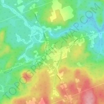
Naam: Topografische kaart Maynooth, hoogte, reliëf.

Locatie: Maynooth, Hastings Highlands, Hastings County, Central Ontario, Ontario, K0L 2S0, Canada (45.21132 -77.95750 45.25132 -77.91750)

Gemiddelde hoogte: 426 m

Minimale hoogte: 372 m

Maximale hoogte: 503 m

Andere topografische kaarten

Klik op een kaart om zijn topografie, zijn hoogte en zijn reliëf te bekijken.

Big Mink Lake

Canada > Ontario > Hastings County > Hastings Highlands

Big Mink Lake, Hastings Highlands, Hastings County, Central Ontario, Ontario, Canada

Gemiddelde hoogte: 446 m

Lake St. Peter

Canada > Ontario > Hastings County > Hastings Highlands

Lake St. Peter, Hastings Highlands, Hastings County, Central Ontario, Ontario, Canada

Gemiddelde hoogte: 420 m

Birds Creek

Canada > Ontario > Hastings County > Hastings Highlands > Birds Creek

Birds Creek, Hastings Highlands, Hastings County, Central Ontario, Ontario, Canada

Gemiddelde hoogte: 370 m