
Topografische kaart Rockport
Klik op de kaart om de hoogte weer te geven.
Rockport
The topography of Rockport, Texas, is defined by its flat, coastal terrain, with the city's average elevation being around 20 feet above sea level. The land is largely shaped by the proximity to the Gulf of Mexico, which influences the area's low-lying nature, including some areas below sea level. The surrounding region is characterized by shallow waters, estuaries, and salt marshes, providing rich wildlife habitats. This coastal setting contributes to Rockport's scenic beaches and its status as a popular tourist destination, offering views of the water and nearby islands.
Over deze kaart
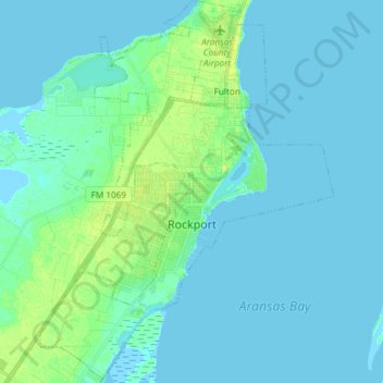
Naam: Topografische kaart Rockport, hoogte, reliëf.
Locatie: Rockport, Aransas County, Texas, United States (27.96631 -97.11330 28.09711 -96.99953)
Gemiddelde hoogte: 3 m
Minimale hoogte: -2 m
Maximale hoogte: 14 m
Andere topografische kaarten
Klik op een kaart om zijn topografie, zijn hoogte en zijn reliëf te bekijken.