
Topografische kaart Big Sky
Interactieve kaart
Klik op de kaart om de hoogte weer te geven.
Over deze kaart
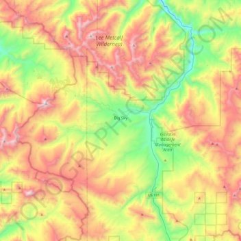
Naam: Topografische kaart Big Sky, hoogte, reliëf.
Locatie: Big Sky, Gallatin County, Montana, United States (45.13076 -111.49439 45.37939 -111.03817)
Gemiddelde hoogte: 2.435 m
Minimale hoogte: 1.689 m
Maximale hoogte: 3.382 m
This climatic region is typified by large seasonal temperature differences, with warm to hot summers and cold (sometimes severely cold) winters. According to the Köppen Climate Classification system, Big Sky has a borderline humid continental (Dfb) / alpine subarctic climate (Dfc). for most of the area, but the lower elevations may be closer to a dry continental climate.
Andere topografische kaarten
Klik op een kaart om zijn topografie, zijn hoogte en zijn reliëf te bekijken.
Logan
United States > Montana > Gallatin County
Logan, Gallatin County, Montana, United States
Gemiddelde hoogte: 1.294 m
Bozeman
United States > Montana > Gallatin County
Bozeman, Gallatin County, Montana, United States
Gemiddelde hoogte: 1.495 m
Three Forks
United States > Montana > Gallatin County
Three Forks, Gallatin County, Montana, United States
Gemiddelde hoogte: 1.249 m
Bozeman
United States > Montana > Gallatin County > Bozeman
Bozeman, Gallatin County, Montana, 59715, United States
Gemiddelde hoogte: 1.679 m
West Yellowstone
United States > Montana > Gallatin County
West Yellowstone, Gallatin County, Montana, United States
Gemiddelde hoogte: 2.034 m