
Topografische kaart Lake Kemp
Interactieve kaart
Klik op de kaart om de hoogte weer te geven.
Over deze kaart
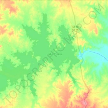
Naam: Topografische kaart Lake Kemp, hoogte, reliëf.
Locatie: Lake Kemp, Baylor County, Texas, United States (33.70608 -99.31874 33.81973 -99.14514)
Gemiddelde hoogte: 360 m
Minimale hoogte: 326 m
Maximale hoogte: 413 m
Andere topografische kaarten
Klik op een kaart om zijn topografie, zijn hoogte en zijn reliëf te bekijken.
Red Springs
United States > Texas > Baylor County
Red Springs, Baylor County, Texas, United States
Gemiddelde hoogte: 418 m
Bomarton
United States > Texas > Baylor County
Bomarton, Baylor County, Texas, United States
Gemiddelde hoogte: 429 m
Westover
United States > Texas > Baylor County
Westover, Baylor County, Texas, United States
Gemiddelde hoogte: 393 m
Mabelle
United States > Texas > Baylor County
Mabelle, Baylor County, Texas, United States
Gemiddelde hoogte: 395 m
Seymour
United States > Texas > Baylor County
Seymour, Baylor County, Texas, 76380, United States
Gemiddelde hoogte: 401 m
Seymour
United States > Texas > Baylor County
Seymour, Baylor County, Texas, 76380, United States
Gemiddelde hoogte: 401 m