
Topografische kaart Bloemfontein
Interactieve kaart
Klik op de kaart om de hoogte weer te geven.
Over deze kaart
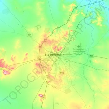
Naam: Topografische kaart Bloemfontein, hoogte, reliëf.
Gemiddelde hoogte: 1.374 m
Minimale hoogte: 1.283 m
Maximale hoogte: 1.593 m
Situated at an elevation of 1,395 m (4,577 ft) above sea level, the city is home to 256,185 (as of 2011) residents and forms part of the Mangaung Metropolitan Municipality which has a population of 747,431. It was one of the host cities for the 2010 FIFA World Cup.