
Topografische kaart River Severn
Interactieve kaart
Klik op de kaart om de hoogte weer te geven.
Over deze kaart
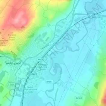
Naam: Topografische kaart River Severn, hoogte, reliëf.
Gemiddelde hoogte: 92 m
Minimale hoogte: 65 m
Maximale hoogte: 178 m
The River Severn (Welsh: Afon Hafren, pronounced [ˈavɔn ˈhavrɛn]), at 220 miles (354 km) long, is the longest river in Great Britain. It is also the river with the most voluminous flow of water by far in all of England and Wales, with an average flow rate of 107 m3/s (3,800 cu ft/s) at Apperley, Gloucestershire. It rises in the Cambrian Mountains in mid Wales, at an altitude of 2,001 feet (610 m), on the Plynlimon massif, which lies close to the Ceredigion/Powys border near Llanidloes. The river then flows through Shropshire, Worcestershire and Gloucestershire. The county towns of Shrewsbury, Worcester and Gloucester lie on its course.
Andere topografische kaarten
Klik op een kaart om zijn topografie, zijn hoogte en zijn reliëf te bekijken.
Powis Castle
United Kingdom > Wales > Powys > Welshpool > Belan
Powis Castle, Red Lane, Belan, Welshpool, Powys, Wales, SY21 8RJ, United Kingdom
Gemiddelde hoogte: 123 m