
Topografische kaart Turpan
Interactieve kaart
Klik op de kaart om de hoogte weer te geven.
Over deze kaart
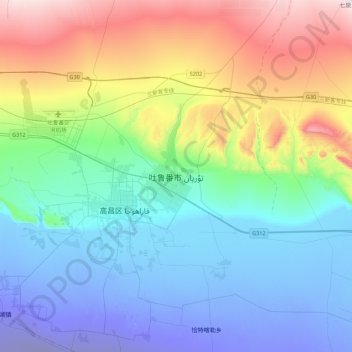
Naam: Topografische kaart Turpan, hoogte, reliëf.
Locatie: Turpan, Gaochang District, Turpan, Xinjiang, 838000, China (42.78003 89.02405 43.10003 89.34405)
Gemiddelde hoogte: 104 m
Minimale hoogte: -141 m
Maximale hoogte: 626 m
Turpan is located about 150 km (93 mi) southeast of Ürümqi, Xinjiang's capital, in a mountain basin, on the northern side of the Turpan Depression, at an elevation of 30 m (98 ft) above sea level. Outside of Turpan is a small volcanic cone, the Turfan volcano, that is said to have erupted in 1120 as described in the Song Dynasty. In June 1995, a book of standard names for local geography was published.