Topografische kaart Attica
Interactieve kaart
Klik op de kaart om de hoogte weer te geven.
Over deze kaart
![Topografische kaart Attica, hoogte, reliëf](/pub/maps/relation/7vf3/wf62kl/thumbnail.jpg)
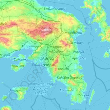
Naam: Topografische kaart Attica, hoogte, reliëf.
Locatie: Attica, Griekenland (37.64831 23.10669 38.34101 24.08594)
Gemiddelde hoogte: 133 m
Minimale hoogte: -1 m
Maximale hoogte: 1.384 m
Andere topografische kaarten
Klik op een kaart om zijn topografie, zijn hoogte en zijn reliëf te bekijken.
![Topografische kaart Δήμος Περάματος, hoogte, reliëf](/pub/maps/relation/sv51/mh7v14/icon.jpg)
Δήμος Περάματος
Griekenland > Attica > Περιφερειακή Ενότητα Πειραιώς
Δήμος Περάματος, Περιφερειακή Ενότητα Πειραιώς, Attica, 188 63, Griekenland
Gemiddelde hoogte: 68 m
![Topografische kaart Athene, hoogte, reliëf](/pub/maps/node/m914/hxp5k/icon.jpg)
Athene
Griekenland > Attica > Περιφερειακή Ενότητα Κεντρικού Τομέα Αθηνών
Athene, Δήμος Αθηναίων, Περιφερειακή Ενότητα Κεντρικού Τομέα Αθηνών, Attica, 105 57, Griekenland
Gemiddelde hoogte: 168 m
![Topografische kaart Νέα Παλάτια, hoogte, reliëf](/pub/maps/node/zztj/lljf3ps8/icon.jpg)
Νέα Παλάτια
Griekenland > Attica > Περιφερειακή Ενότητα Ανατολικής Αττικής
Νέα Παλάτια, Δήμος Ωρωπού, Περιφερειακή Ενότητα Ανατολικής Αττικής, Attica, 190 15, Griekenland
Gemiddelde hoogte: 50 m
![Topografische kaart Κάλαμος, hoogte, reliëf](/pub/maps/node/fqz4/mdm9wv1h/icon.jpg)
Κάλαμος
Griekenland > Attica > Περιφερειακή Ενότητα Ανατολικής Αττικής
Κάλαμος, Δήμος Ωρωπού, Περιφερειακή Ενότητα Ανατολικής Αττικής, Attica, 190 17, Griekenland
Gemiddelde hoogte: 242 m
![Topografische kaart Σπέτσες, hoogte, reliëf](/pub/maps/relation/bfnx/zs1mt/icon.jpg)
Σπέτσες
Griekenland > Attica > Περιφερειακή Ενότητα Νήσων > Σπέτσες
Σπέτσες, Δήμος Σπετσών, Περιφερειακή Ενότητα Νήσων, Attica, 180 50, Griekenland
Gemiddelde hoogte: 33 m
![Topografische kaart Olympus, hoogte, reliëf](/pub/maps/node/rknx/lsx5pdgt/icon.jpg)
Olympus
Griekenland > Attica > Περιφερειακή Ενότητα Βορείου Τομέα Αθηνών > Δημοτική Ενότητα Ψυχικού
Olympus, Δημοτική Ενότητα Ψυχικού, Δήμος Φιλοθέης - Ψυχικού, Περιφερειακή Ενότητα Βορείου Τομέα Αθηνών, Attica, 154 52, Griekenland
Gemiddelde hoogte: 204 m
![Topografische kaart Piraeus, hoogte, reliëf](/pub/maps/node/sb51/jvl755k/icon.jpg)
Piraeus
Griekenland > Attica > Περιφερειακή Ενότητα Πειραιώς
Piraeus, Δήμος Πειραιώς, Περιφερειακή Ενότητα Πειραιώς, Attica, 185 35, Griekenland
Gemiddelde hoogte: 96 m
![Topografische kaart Σαλαμίνα, hoogte, reliëf](/pub/maps/relation/3p51/tf3qdn/icon.jpg)
Σαλαμίνα
Griekenland > Attica > Περιφερειακή Ενότητα Νήσων > Δημοτική Ενότητα Αμπελακίων
Σαλαμίνα, Δημοτική Ενότητα Αμπελακίων, Δήμος Σαλαμίνας, Περιφερειακή Ενότητα Νήσων, Attica, Griekenland
Gemiddelde hoogte: 38 m
![Topografische kaart Νέα Μάκρη, hoogte, reliëf](/pub/maps/node/k5f3/jr168zs/icon.jpg)
Νέα Μάκρη
Griekenland > Attica > Περιφερειακή Ενότητα Ανατολικής Αττικής > Δημοτική Ενότητα Νέας Μάκρης
Νέα Μάκρη, Δημοτική Ενότητα Νέας Μάκρης, Marathónas, Περιφερειακή Ενότητα Ανατολικής Αττικής, Attica, 190 05, Griekenland
Gemiddelde hoogte: 122 m
![Topografische kaart Μαραθώνας, hoogte, reliëf](/pub/maps/node/rv3q/llb54zs8/icon.jpg)
Μαραθώνας
Griekenland > Attica > Μαραθώνας
Μαραθώνας, Marathónas, Περιφερειακή Ενότητα Ανατολικής Αττικής, Attica, 19007, Griekenland
Gemiddelde hoogte: 157 m