
Topografische kaart Brooks
Interactieve kaart
Klik op de kaart om de hoogte weer te geven.
Over deze kaart
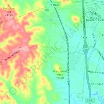
Naam: Topografische kaart Brooks, hoogte, reliëf.
Locatie: Brooks, Bullitt County, Kentucky, 40109, United States (38.03565 -85.74555 38.08717 -85.69930)
Gemiddelde hoogte: 189 m
Minimale hoogte: 138 m
Maximale hoogte: 280 m
Andere topografische kaarten
Klik op een kaart om zijn topografie, zijn hoogte en zijn reliëf te bekijken.
Shepherdsville
United States > Kentucky > Bullitt County
Shepherdsville, Bullitt County, Kentucky, United States
Gemiddelde hoogte: 148 m
Hillview
United States > Kentucky > Bullitt County
Hillview, Bullitt County, Kentucky, United States
Gemiddelde hoogte: 162 m
Mount Washington
United States > Kentucky > Bullitt County
Mount Washington, Bullitt County, Kentucky, 40047, United States
Gemiddelde hoogte: 184 m
Bernheim Forest
United States > Kentucky > Bullitt County
Bernheim Forest, Bullitt County, Kentucky, United States
Gemiddelde hoogte: 230 m
Salt River
United States > Kentucky > Bullitt County > Shepherdsville
Salt River, Shepherdsville, Bullitt County, Kentucky, 40165, United States
Gemiddelde hoogte: 140 m
Phelps Knob
United States > Kentucky > Bullitt County
Phelps Knob, Bullitt County, Kentucky, 40165, United States
Gemiddelde hoogte: 161 m
Dawson Knob
United States > Kentucky > Bullitt County
Dawson Knob, Bullitt County, Kentucky, United States
Gemiddelde hoogte: 203 m