
Topografische kaart Fullers
Interactieve kaart
Klik op de kaart om de hoogte weer te geven.
Over deze kaart
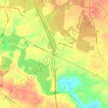
Naam: Topografische kaart Fullers, hoogte, reliëf.
Gemiddelde hoogte: 90 m
Minimale hoogte: 52 m
Maximale hoogte: 112 m
Andere topografische kaarten
Klik op een kaart om zijn topografie, zijn hoogte en zijn reliëf te bekijken.
Westmere
United States > New York > Albany County > Town of Guilderland
Westmere, Town of Guilderland, Albany County, New York, United States
Gemiddelde hoogte: 79 m
Village of Altamont
United States > New York > Albany County > Town of Guilderland
Village of Altamont, Town of Guilderland, Albany County, New York, United States
Gemiddelde hoogte: 158 m
Fort Hunter
United States > New York > Albany County > Town of Guilderland
Fort Hunter, Town of Guilderland, Albany County, New York, 12303, United States
Gemiddelde hoogte: 99 m
North Bethlehem
United States > New York > Albany County > Town of Guilderland
North Bethlehem, Town of Guilderland, Albany County, New York, 12203, United States
Gemiddelde hoogte: 65 m
Meadowdale
United States > New York > Albany County > Town of Guilderland
Meadowdale, Town of Guilderland, Albany County, New York, 12085, United States
Gemiddelde hoogte: 115 m
Dunnsville
United States > New York > Albany County > Town of Guilderland
Dunnsville, Town of Guilderland, Albany County, New York, 12009, United States
Gemiddelde hoogte: 130 m
Hartmans Corners
United States > New York > Albany County > Town of Guilderland
Hartmans Corners, Town of Guilderland, Albany County, New York, 12084, United States
Gemiddelde hoogte: 81 m
Guilderland Center
United States > New York > Albany County > Town of Guilderland
Guilderland Center, Town of Guilderland, Albany County, New York, 12085, United States
Gemiddelde hoogte: 96 m