
Topografische kaart Mulaló
Interactieve kaart
Klik op de kaart om de hoogte weer te geven.
Over deze kaart
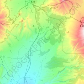
Naam: Topografische kaart Mulaló, hoogte, reliëf.
Locatie: Mulaló, Latacunga, Cotopaxi, Ecuador (-0.83377 -78.62311 -0.59284 -78.38093)
Gemiddelde hoogte: 3.430 m
Minimale hoogte: 2.879 m
Maximale hoogte: 4.898 m
Andere topografische kaarten
Klik op een kaart om zijn topografie, zijn hoogte en zijn reliëf te bekijken.
San Felipe
Ecuador > Cotopaxi > Latacunga > Latacunga > San Felipe
San Felipe, Latacunga, Cotopaxi, EC050101, Ecuador
Gemiddelde hoogte: 2.820 m
Volcán Cotopaxi
Ecuador > Cotopaxi > Latacunga > Mulaló
Volcán Cotopaxi, Mulaló, Latacunga, Cotopaxi, Ecuador
Gemiddelde hoogte: 5.021 m