
Topografische kaart Ciudad Victoria
Interactieve kaart
Klik op de kaart om de hoogte weer te geven.
Ciudad Victoria
Ciudad Victoria has a climate on the border of humid subtropical (Köppen Cfa/Cwa) and hot semi-arid (BSh). Its weather is characterised by short warm winters and long hot to sweltering summers. Temperatures rarely drop below 0 °C (32 °F) — the lowest recorded temperature was −6 °C (21.2 °F) and the hottest was 48.5 °C (119.3 °F), one of the highest temperatures ever recorded in Mexico. The average annual rainfall is 740 millimetres or 29 inches, of which five-sixths (617 millimetres or 24.3 inches) falls between May and October, although there is a drying trend in the months of July and August. The moderate elevation adds to overall rainfall pattern, which is also influenced by exceptionally heavy rains brought by occasional North Atlantic tropical cyclones.
Over deze kaart
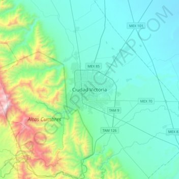
Naam: Topografische kaart Ciudad Victoria, hoogte, reliëf.
Locatie: Ciudad Victoria, Victoria, Tamaulipas, 87000, Mexico (23.57898 -99.30414 23.89898 -98.98414)
Gemiddelde hoogte: 518 m
Minimale hoogte: 163 m
Maximale hoogte: 2.149 m