
Topografische kaart Ford City
Interactieve kaart
Klik op de kaart om de hoogte weer te geven.
Over deze kaart
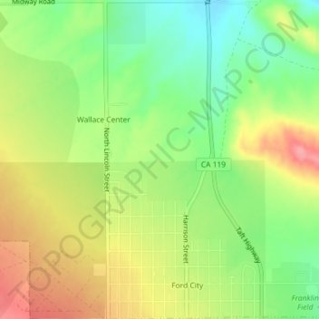
Naam: Topografische kaart Ford City, hoogte, reliëf.
Locatie: Ford City, Taft, Kern County, California, United States (35.15126 -119.46548 35.18064 -119.44785)
Gemiddelde hoogte: 264 m
Minimale hoogte: 219 m
Maximale hoogte: 314 m
Ford City is a census-designated place (CDP) in Kern County, California, United States. Ford City is located 1 mile (1.61 km) north of Taft, at an elevation of 892 feet (272 m). The population was 4,348 at the 2020 census, up from 4,278 at the 2010 census. It is immediately north of Taft, between the huge Midway-Sunset Oil Field to the southwest, and the almost exhausted Buena Vista Oil Field to the northeast. State Route 119 passes east of town from its junction with SR 33 to the south.
Andere topografische kaarten
Klik op een kaart om zijn topografie, zijn hoogte en zijn reliëf te bekijken.
South Taft
United States > California > Kern County > Taft > South Taft
South Taft, Taft, Kern County, California, United States
Gemiddelde hoogte: 343 m
Taft Heights
United States > California > Kern County > Taft > Taft Heights
Taft Heights, Taft, Kern County, California, United States
Gemiddelde hoogte: 368 m