
Topografische kaart Iztaccíhuatl
Interactieve kaart
Klik op de kaart om de hoogte weer te geven.
Over deze kaart
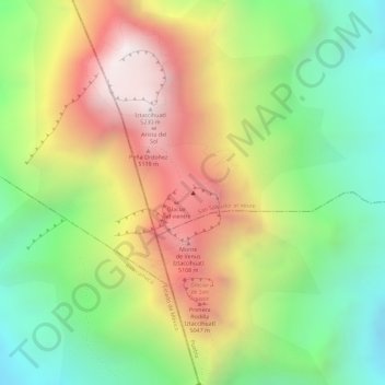
Naam: Topografische kaart Iztaccíhuatl, hoogte, reliëf.
Locatie: Iztaccíhuatl, San Salvador el Verde, Puebla, Mexico (19.17015 -98.63764 19.17025 -98.63754)
Gemiddelde hoogte: 4.732 m
Minimale hoogte: 4.293 m
Maximale hoogte: 5.221 m
The name "Iztaccíhuatl" is Nahuatl for "White woman", reflecting the four individual snow-capped peaks which depict the head, chest, knees and feet of a sleeping female when seen from east or west. Iztaccíhuatl is to the north of its twin Popocatépetl, to which it is connected by the high altitude Paso de Cortés. Depending on atmospheric conditions Iztaccíhuatl is visible much of the year from Mexico City some 70 km (43 mi) to the northwest. The first recorded ascent was made in 1889, though archaeological evidence suggests the Aztecs and previous cultures climbed it previously. It is the lowest peak containing permanent snow and glaciers in Mexico.
Andere topografische kaarten
Klik op een kaart om zijn topografie, zijn hoogte en zijn reliëf te bekijken.
Cerro Tehuicocone
Mexico > Puebla > San Salvador el Verde
Cerro Tehuicocone, San Salvador el Verde, Puebla, Mexico
Gemiddelde hoogte: 4.260 m