
Topografische kaart Belcoo
Interactieve kaart
Klik op de kaart om de hoogte weer te geven.
Over deze kaart
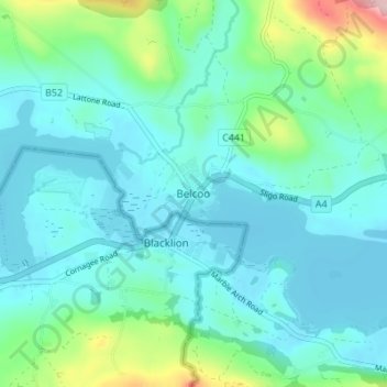
Naam: Topografische kaart Belcoo, hoogte, reliëf.
Gemiddelde hoogte: 86 m
Minimale hoogte: 47 m
Maximale hoogte: 260 m
Andere topografische kaarten
Klik op een kaart om zijn topografie, zijn hoogte en zijn reliëf te bekijken.
Brookeborough
United Kingdom > Northern Ireland > County Fermanagh
Brookeborough, County Fermanagh, Northern Ireland, BT94 4EZ, United Kingdom
Gemiddelde hoogte: 97 m
Brattan's Hill
United Kingdom > Northern Ireland > County Fermanagh
Brattan's Hill, Ardunshin, County Fermanagh, Northern Ireland, BT94 4RT, United Kingdom
Gemiddelde hoogte: 79 m
White Island
United Kingdom > Northern Ireland > County Fermanagh
White Island, County Fermanagh, Ulster, Northern Ireland, United Kingdom
Gemiddelde hoogte: 48 m
Lough Navar
United Kingdom > Northern Ireland > County Fermanagh
Lough Navar, Barr of Drumbadmeen, County Fermanagh, Ulster, Northern Ireland, United Kingdom
Gemiddelde hoogte: 232 m
Carr
United Kingdom > Northern Ireland > County Fermanagh
Carr, County Fermanagh, Northern Ireland, United Kingdom
Gemiddelde hoogte: 60 m
Ederney
United Kingdom > Northern Ireland > County Fermanagh
Ederney, County Fermanagh, Northern Ireland, BT93 0DG, United Kingdom
Gemiddelde hoogte: 91 m
Tempo
United Kingdom > Northern Ireland > County Fermanagh > Tempo
Tempo, County Fermanagh, Northern Ireland, BT94 3LU, United Kingdom
Gemiddelde hoogte: 127 m
Bellanaleck
United Kingdom > Northern Ireland > County Fermanagh
Bellanaleck, County Fermanagh, Ulster, Northern Ireland, BT92 2BA, United Kingdom
Gemiddelde hoogte: 54 m
Irvinestown
United Kingdom > Northern Ireland > County Fermanagh
Irvinestown, County Fermanagh, Ulster, Northern Ireland, BT94 1GS, United Kingdom
Gemiddelde hoogte: 95 m
Derrygonnelly
United Kingdom > Northern Ireland > County Fermanagh
Derrygonnelly, County Fermanagh, Ulster, Northern Ireland, BT93 6HW, United Kingdom
Gemiddelde hoogte: 79 m
Cuilcagh
United Kingdom > Northern Ireland > County Fermanagh
Cuilcagh, Cavan-Belturbet Municipal District, County Cavan, Ireland
Gemiddelde hoogte: 472 m