
Doe een donatie
Rust jezelf uit voor je volgende avontuur:
Als Amazon-partner verdient deze site een commissie op in aanmerking komende aankopen, zonder extra kosten voor jou.
Topografische kaart Darwen
Klik op de kaart om de hoogte weer te geven.
Doe een donatie
Rust jezelf uit voor je volgende avontuur:
Als Amazon-partner verdient deze site een commissie op in aanmerking komende aankopen, zonder extra kosten voor jou.
Darwen
The tower, which is open to the public, overlooks the town from the moors and stands at an altitude of 1,227 ft (374m) and has a height of 85 ft (26m). A spiral staircase leads to the top from where, on a clear day, Blackpool Tower, the Isle of Man, North Wales and the Furness Peninsula can be seen. In November 2010 the dome of the tower was blown off by strong winds. The dome was restored in January 2012.[27]
Doe een donatie
Rust jezelf uit voor je volgende avontuur:
Als Amazon-partner verdient deze site een commissie op in aanmerking komende aankopen, zonder extra kosten voor jou.
Over deze kaart
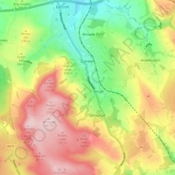
Naam: Topografische kaart Darwen, hoogte, reliëf.
Gemiddelde hoogte: 259 m
Minimale hoogte: 123 m
Maximale hoogte: 402 m
Doe een donatie
Rust jezelf uit voor je volgende avontuur:
Als Amazon-partner verdient deze site een commissie op in aanmerking komende aankopen, zonder extra kosten voor jou.
Andere topografische kaarten
Klik op een kaart om zijn topografie, zijn hoogte en zijn reliëf te bekijken.
Winter Hill
United Kingdom > England > Blackburn with Darwen > Belmont
Paths to the summit lead from Belmont (in Blackburn with Darwen), Rivington (in Chorley), and Horwich and Blackrod (in Bolton). The summit can also be reached via a short walk from the top of a road pass 1+1⁄4 miles (2 km) west of Belmont. The hill is a prominent natural landmark on the skyline for the most…
Gemiddelde hoogte: 357 m
Turton & Entwistle Reservoir
United Kingdom > England > Blackburn with Darwen
Gemiddelde hoogte: 248 m
Doe een donatie
Rust jezelf uit voor je volgende avontuur:
Als Amazon-partner verdient deze site een commissie op in aanmerking komende aankopen, zonder extra kosten voor jou.
Doe een donatie
Rust jezelf uit voor je volgende avontuur:
Als Amazon-partner verdient deze site een commissie op in aanmerking komende aankopen, zonder extra kosten voor jou.
Winter Hill
United Kingdom > England > Blackburn with Darwen > Belmont
Paths to the summit lead from Belmont (in Blackburn with Darwen), Rivington (in Chorley), and Horwich and Blackrod (in Bolton). The summit can also be reached via a short walk from the top of a road pass 1+1⁄4 miles (2 km) west of Belmont. The hill is a prominent natural landmark on the skyline for the most…
Gemiddelde hoogte: 357 m
Winter Hill
United Kingdom > England > Blackburn with Darwen > Tockholes
Paths to the summit lead from Belmont (in Blackburn with Darwen), Rivington (in Chorley), and Horwich and Blackrod (in Bolton). The summit can also be reached via a short walk from the top of a road pass 1+1⁄4 miles (2 km) west of Belmont. The hill is a prominent natural landmark on the skyline for the most…
Gemiddelde hoogte: 205 m
Doe een donatie
Rust jezelf uit voor je volgende avontuur:
Als Amazon-partner verdient deze site een commissie op in aanmerking komende aankopen, zonder extra kosten voor jou.
Winter Hill
United Kingdom > England > Blackburn with Darwen > Tockholes
Paths to the summit lead from Belmont (in Blackburn with Darwen), Rivington (in Chorley borough), and Horwich and Blackrod (in Bolton borough). The summit can also be reached via a short walk from the top of a road pass 1+1⁄4 miles (2 km) west of Belmont. The hill is a prominent feature on the skyline for…
Gemiddelde hoogte: 205 m
Higher Springfield
United Kingdom > England > Blackburn with Darwen > Guide > Higher Springfield
Gemiddelde hoogte: 202 m
Doe een donatie
Rust jezelf uit voor je volgende avontuur:
Als Amazon-partner verdient deze site een commissie op in aanmerking komende aankopen, zonder extra kosten voor jou.
Oakdale
United Kingdom > England > Blackburn with Darwen > Lower Darwen > Oakdale
Gemiddelde hoogte: 163 m
Electricty Northwest
United Kingdom > England > Blackburn with Darwen > Belmont
Gemiddelde hoogte: 356 m
Doe een donatie
Rust jezelf uit voor je volgende avontuur:
Als Amazon-partner verdient deze site een commissie op in aanmerking komende aankopen, zonder extra kosten voor jou.