
Doe een donatie
Rust jezelf uit voor je volgende avontuur:
Als Amazon-partner verdient deze site een commissie op in aanmerking komende aankopen, zonder extra kosten voor jou.
Topografische kaart Clarkston
Klik op de kaart om de hoogte weer te geven.
Doe een donatie
Rust jezelf uit voor je volgende avontuur:
Als Amazon-partner verdient deze site een commissie op in aanmerking komende aankopen, zonder extra kosten voor jou.
Over deze kaart
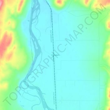
Naam: Topografische kaart Clarkston, hoogte, reliëf.
Locatie: Clarkston, Gallatin County, Montana, United States (46.00993 -111.43358 46.04993 -111.39358)
Gemiddelde hoogte: 1.236 m
Minimale hoogte: 1.208 m
Maximale hoogte: 1.332 m
Doe een donatie
Rust jezelf uit voor je volgende avontuur:
Als Amazon-partner verdient deze site een commissie op in aanmerking komende aankopen, zonder extra kosten voor jou.
Andere topografische kaarten
Klik op een kaart om zijn topografie, zijn hoogte en zijn reliëf te bekijken.
Bozeman
United States > Montana > Gallatin County
Bozeman is located at an elevation of 4,820 feet (1,470 m). The Bridger Mountains are to the north-northeast, the Tobacco Root Mountains to the west-southwest, the Big Belt Mountains and Horseshoe Hills to the northwest, the Hyalite Peaks of the northern Gallatin Range to the south and the Spanish Peaks of the…
Gemiddelde hoogte: 1.495 m
Big Sky
United States > Montana > Gallatin County
Big Sky is characterized by its dramatic and diverse topography, which forms part of the northern Rocky Mountains. The area features an elevation that ranges from around 5,500 feet in the valleys to more than 11,000 feet at its peaks, including the notable Lone Peak. This mountainous terrain is interspersed…
Gemiddelde hoogte: 2.435 m
Doe een donatie
Rust jezelf uit voor je volgende avontuur:
Als Amazon-partner verdient deze site een commissie op in aanmerking komende aankopen, zonder extra kosten voor jou.
Doe een donatie
Rust jezelf uit voor je volgende avontuur:
Als Amazon-partner verdient deze site een commissie op in aanmerking komende aankopen, zonder extra kosten voor jou.
Bozeman
United States > Montana > Gallatin County
Bozeman is located at an elevation of 4,820 feet (1,470 m). The Bridger Mountains are to the north-northeast, the Tobacco Root Mountains to the west-southwest, the Big Belt Mountains and Horseshoe Hills to the northwest, the Hyalite Peaks of the northern Gallatin Range to the south and the Spanish Peaks of the…
Gemiddelde hoogte: 1.495 m
Doe een donatie
Rust jezelf uit voor je volgende avontuur:
Als Amazon-partner verdient deze site een commissie op in aanmerking komende aankopen, zonder extra kosten voor jou.
Big Sky
United States > Montana > Gallatin County
Big Sky is located close to the Yellowstone National Park along the western edge of Gallatin County and eastern edge of Madison County, on U.S. Highway 191. It is approximately midway between West Yellowstone and Bozeman, being around 45 miles (72 km) by road from each. It sits within the Madison Range, with…
Gemiddelde hoogte: 2.439 m
Bozeman
United States > Montana > Gallatin County
Bozeman is located at an elevation of 4,820 feet or 1,470 metres. The Bridger Mountains are to the north-northeast, the Tobacco Root Mountains to the west-south-west, the Big Belt Mountains and Horseshoe Hills to the northwest, the Hyalite Peaks of the northern Gallatin Range to the south and the Spanish Peaks…
Gemiddelde hoogte: 1.495 m