
Topografische kaart Río Grande
Interactieve kaart
Klik op de kaart om de hoogte weer te geven.
Over deze kaart
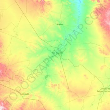
Naam: Topografische kaart Río Grande, hoogte, reliëf.
Locatie: Río Grande, Zacatecas, 98400, Mexico (23.55942 -103.39197 24.06550 -102.67373)
Gemiddelde hoogte: 2.059 m
Minimale hoogte: 1.748 m
Maximale hoogte: 2.663 m
Over 96% of the municipality's area lies in the drainage basin of the Aguanaval River, the main watercourse in the area which flows south to north through the municipality. This river was known as the Río Grande in the 16th and 17th centuries despite its modest size. The highest point in the municipality is the Cerro Tetilla Grande located at 23°41′N 102°51′W / 23.683°N 102.850°W / 23.683; -102.850 with an elevation of 2,370 metres (7,780 ft) above sea level.
Andere topografische kaarten
Klik op een kaart om zijn topografie, zijn hoogte en zijn reliëf te bekijken.
Pozo Hondo
Mexico > Zacatecas > Villa de Cos
Pozo Hondo, Villa de Cos, Zacatecas, Mexico
Gemiddelde hoogte: 2.032 m