
Topografische kaart Ua Pou
Interactieve kaart
Klik op de kaart om de hoogte weer te geven.
Over deze kaart
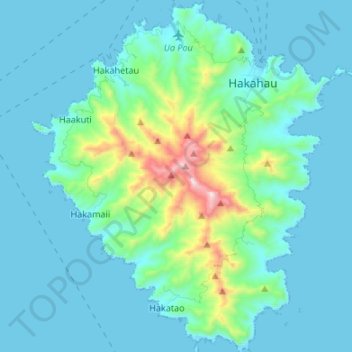
Naam: Topografische kaart Ua Pou, hoogte, reliëf.
Locatie: Ua Pou, Marquesas Islands, French Polynesia, France (-9.46723 -140.13578 -9.33490 -140.01976)
Gemiddelde hoogte: 127 m
Minimale hoogte: -4 m
Maximale hoogte: 919 m
It is located about 50 km (30 mi.) south of Nuku Hiva, in the northern Marquesas. The center of the island is characterized by four high basalt pillars that reach high above the surrounding mountains. The highest of these pillars, Mount Oave (Mont Oave), reaches to 1,230 m (4,040 ft) above sea level and is the highest elevation in the Marquesas.