
Topografische kaart Cut Bank
Interactieve kaart
Klik op de kaart om de hoogte weer te geven.
Over deze kaart
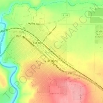
Naam: Topografische kaart Cut Bank, hoogte, reliëf.
Locatie: Cut Bank, Glacier County, Montana, United States (48.62381 -112.34579 48.64705 -112.31473)
Gemiddelde hoogte: 1.147 m
Minimale hoogte: 1.083 m
Maximale hoogte: 1.198 m
Cut Bank experiences a semi-arid climate (Köppen BSk) with long, cold, dry winters and short, warm, wetter summers. In winter, bitterly cold arctic air masses move south and impact the eastern side of the American Continental Divide. During such invasions Cut Bank, with its comparatively high elevation and topography is frequently the coldest location in the lower 48 U.S. States. Being close to the eastern slopes of the Rocky Mountains also makes the area subject to occasional Chinook winds that can rapidly increase the local temperature.
Andere topografische kaarten
Klik op een kaart om zijn topografie, zijn hoogte en zijn reliëf te bekijken.
Pray Lake
United States > Montana > Glacier County
Pray Lake, Glacier County, Montana, United States
Gemiddelde hoogte: 1.717 m
Basin Mountain
United States > Montana > Glacier County
Basin Mountain, Glacier County, Montana, United States
Gemiddelde hoogte: 2.075 m