
Topografische kaart Les Closerons
Interactieve kaart
Klik op de kaart om de hoogte weer te geven.
Over deze kaart
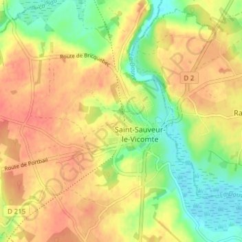
Naam: Topografische kaart Les Closerons, hoogte, reliëf.
Gemiddelde hoogte: 28 m
Minimale hoogte: -1 m
Maximale hoogte: 49 m
Andere topografische kaarten
Klik op een kaart om zijn topografie, zijn hoogte en zijn reliëf te bekijken.
Selsoif
France > Normandie > Manche > Saint-Sauveur-le-Vicomte
Selsoif, Saint-Sauveur-le-Vicomte, Cherbourg, Manche, Normandie, France métropolitaine, 50390, France
Gemiddelde hoogte: 11 m
Voie Verte
France > Normandie > Manche > Saint-Sauveur-le-Vicomte > Les Closerons
Voie Verte, Chemin rural dit des Closerons, Les Closerons, Saint-Sauveur-le-Vicomte, Cherbourg, Manche, Normandie, France métropolitaine, 50390, France
Gemiddelde hoogte: 23 m
Le Paradis
France > Normandie > Manche > Saint-Sauveur-le-Vicomte
Le Paradis, Saint-Sauveur-le-Vicomte, Cherbourg, Manche, Normandie, France métropolitaine, 50390, France
Gemiddelde hoogte: 26 m
Le Planitre
France > Normandie > Manche > Saint-Sauveur-le-Vicomte
Le Planitre, Saint-Sauveur-le-Vicomte, Cherbourg, Manche, Normandie, France métropolitaine, 50390, France
Gemiddelde hoogte: 36 m