
Topografische kaart South Bend
Interactieve kaart
Klik op de kaart om de hoogte weer te geven.
Over deze kaart
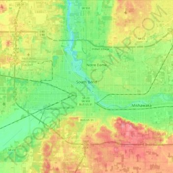
Naam: Topografische kaart South Bend, hoogte, reliëf.
Locatie: South Bend, Saint Joseph County, Indiana, United States (41.59745 -86.36075 41.76027 -86.19129)
Gemiddelde hoogte: 236 m
Minimale hoogte: 199 m
Maximale hoogte: 283 m
On September 29, 1929, South Bend completed its "track elevation program". This was a railroad infrastructure project which saw the removal of Grand Trunk Western Railroad tracks from Division Street, the removal of level crossings from Chapin to Miami streets, the creation of a modern freight layout, and the construction of Union Station. This project had been seventeen years in the making, and had been the subject of the Indiana Supreme Court case Vandalia Railroad v. South Bend, which was subsequently affirmed by the Supreme Court of the United States.
Andere topografische kaarten
Klik op een kaart om zijn topografie, zijn hoogte en zijn reliëf te bekijken.
Walkerton
United States > Indiana > Saint Joseph County
Walkerton, Saint Joseph County, Indiana, 46574, United States
Gemiddelde hoogte: 218 m
Granger
United States > Indiana > Saint Joseph County > Granger
Granger, Milton Township, Saint Joseph County, Indiana, 46530, United States
Gemiddelde hoogte: 240 m
Chain-O-Lakes
United States > Indiana > Saint Joseph County > Chain-O-Lakes
Chain-O-Lakes, Saint Joseph County, Indiana, United States
Gemiddelde hoogte: 231 m