
Doe een donatie
Rust jezelf uit voor je volgende avontuur:
Als Amazon-partner verdient deze site een commissie op in aanmerking komende aankopen, zonder extra kosten voor jou.
Topografische kaart Behchokǫ̀
Klik op de kaart om de hoogte weer te geven.
Doe een donatie
Rust jezelf uit voor je volgende avontuur:
Als Amazon-partner verdient deze site een commissie op in aanmerking komende aankopen, zonder extra kosten voor jou.
Behchokǫ̀
As the community grew alongside increased services such as a mission-run hospital and church, the government viewed the topography of Fort Rae as unsuitable for expansion. In the 1950s there was concern about runoff from animal and human wastes contaminating sources of drinking water, and the government proposed constructing a new settlement on more favourable terrain. The community became known as Edzo and was located on the west side of the Frank Channel opposite Fort Rae a 24 km (15 mi) drive away. Most of the Dene families refused to move from their community so that Rae (62°49′43″N 116°03′08″W / 62.82861°N 116.05222°W / 62.82861; -116.05222 (Rae)) and Edzo (62°46′30″N 116°02′26″W / 62.77500°N 116.04056°W / 62.77500; -116.04056 (Edzo)) (Rae-Edzo) became two separate communities although administered together.
Doe een donatie
Rust jezelf uit voor je volgende avontuur:
Als Amazon-partner verdient deze site een commissie op in aanmerking komende aankopen, zonder extra kosten voor jou.
Over deze kaart
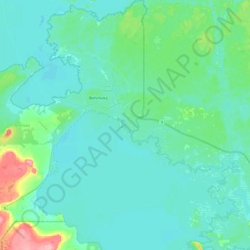
Naam: Topografische kaart Behchokǫ̀, hoogte, reliëf.
Gemiddelde hoogte: 169 m
Minimale hoogte: 152 m
Maximale hoogte: 257 m
Doe een donatie
Rust jezelf uit voor je volgende avontuur:
Als Amazon-partner verdient deze site een commissie op in aanmerking komende aankopen, zonder extra kosten voor jou.