
Topografische kaart South-West Oxford
Interactieve kaart
Klik op de kaart om de hoogte weer te geven.
Over deze kaart
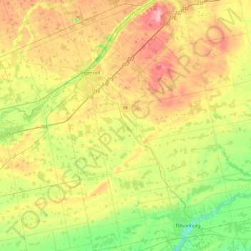
Naam: Topografische kaart South-West Oxford, hoogte, reliëf.
Gemiddelde hoogte: 281 m
Minimale hoogte: 201 m
Maximale hoogte: 388 m
In its wilderness state, the former Dereham township had thousands of acres of swamp and marsh land which limited its use for agriculture. Several large drainage projects brought great improvement and remain as essential parts of the township's farmland infrastructure. The township topography still has several large forested areas which are remnants of the original swamps on which drainage system runoff is concentrated.
Andere topografische kaarten
Klik op een kaart om zijn topografie, zijn hoogte en zijn reliëf te bekijken.
Sweaburg
Canada > Ontario > Oxford County > South-West Oxford
Sweaburg, South-West Oxford, Oxford County, Ontario, N0J 1A0, Canada
Gemiddelde hoogte: 317 m
Mount Elgin
Canada > Ontario > Oxford County > South-West Oxford
Mount Elgin, South-West Oxford, Oxford County, Ontario, N0J 1N0, Canada
Gemiddelde hoogte: 281 m
Salford
Canada > Ontario > Oxford County > South-West Oxford
Salford, South-West Oxford, Oxford County, Southwestern Ontario, Ontario, N5C 3J8, Canada
Gemiddelde hoogte: 291 m
Beachville
Canada > Ontario > Oxford County > South-West Oxford
Beachville, South-West Oxford, Oxford County, Southwestern Ontario, Ontario, N5C 3K1, Canada
Gemiddelde hoogte: 303 m