
Topografische kaart Yamuna River
Interactieve kaart
Klik op de kaart om de hoogte weer te geven.
Over deze kaart
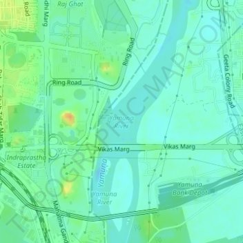
Naam: Topografische kaart Yamuna River, hoogte, reliëf.
Locatie: Yamuna River, Delhi, India (28.62859 77.25325 28.63338 77.25951)
Gemiddelde hoogte: 206 m
Minimale hoogte: 197 m
Maximale hoogte: 229 m
The source of Yamuna lies in the Yamunotri Glacier at an elevation of 6,387 metres (20,955 ft), on the southwestern slopes of Banderpooch peaks, which lie in the Mussoorie range of the Lower Himalayas, north of Haridwar in Uttarkashi district, Uttarakhand. Yamunotri temple, a shrine dedicated to the goddess Yamuna, is one of the holiest shrines in Hinduism, and part of the Chota Char Dham Yatra circuit. Also standing close to the temple, on its 13-kilometre (8 mi) trek route that follows the right bank of the river, lies Markendeya Tirtha, where the sage Markandeya wrote the Markandeya Purana.
Andere topografische kaarten
Klik op een kaart om zijn topografie, zijn hoogte en zijn reliëf te bekijken.
Shalimar Bagh
Shalimar Bagh, Delhi, Saraswati Vihar Tehsil, North West Delhi, Delhi, 110088, India
Gemiddelde hoogte: 217 m