
Topografische kaart Bellingham
Interactieve kaart
Klik op de kaart om de hoogte weer te geven.
Over deze kaart
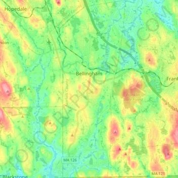
Naam: Topografische kaart Bellingham, hoogte, reliëf.
Gemiddelde hoogte: 84 m
Minimale hoogte: 45 m
Maximale hoogte: 153 m
According to the United States Census Bureau, the town has a total area of 19.0 square miles (49.2 km2), of which 18.5 square miles (47.9 km2) is land and 0.5 square mile (1.3 km2) (2.58%) is water. The town's mean elevation is 293 feet (89 m) above sea level.