
Topografische kaart Les Carrières
Interactieve kaart
Klik op de kaart om de hoogte weer te geven.
Over deze kaart
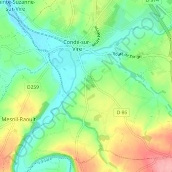
Naam: Topografische kaart Les Carrières, hoogte, reliëf.
Gemiddelde hoogte: 61 m
Minimale hoogte: 19 m
Maximale hoogte: 137 m
Andere topografische kaarten
Klik op een kaart om zijn topografie, zijn hoogte en zijn reliëf te bekijken.
Le Hamel
France > Normandie > Manche > Condé-sur-Vire > Les Carrières
Le Hamel, Les Carrières, Condé-sur-Vire, Saint-Lô, Manche, Normandie, France métropolitaine, 50890, France
Gemiddelde hoogte: 51 m
La Belinière
France > Normandie > Manche > Condé-sur-Vire
La Belinière, Condé-sur-Vire, Saint-Lô, Manche, Normandie, France métropolitaine, 50890, France
Gemiddelde hoogte: 61 m